San Cristóbal geodata
San Cristóbal (Oaxaca) is a populated place; located in Mexico in America/Mexico_City (GMT-6) time zone. With population of 867 people, there are 10083 cities with bigger population in this country. Compared to other cities in Mexico, 94.7% of cities are located further ↑North; 83.1% of cities are located further ←West and 76.5% of cities have higher elevation than San Cristóbal. Note1


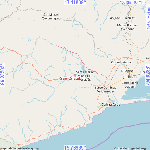
San Cristóbal GPS coordinates[2]
16° 26' 41.676" North, 95° 31' 54.912" West
| Map corner | latitude | longitude |
|---|---|---|
| Upper-left | 17.11809°, | -96.23505° |
| Center: | 16.44491°, | -95.53192° |
| Lower-right: | 15.76939°, | -94.8288° |
| Map W x H: | 150×150 km | = 93.2×93.2mi |
| max Lat: | 32.7° ⇑94.7% North |
| San Cristóbal: | 16.44491° |
| min Lat: | ⇓5.3% South 14.53588° |
| min Long | San Cristóbal | max Long |
| -117.105° | -95.53192° | -86.73105° |
| W 83.1%⇐ | ⇒16.9% E |
Elevation
Elevation of San Cristóbal is 169 m = 554 ft, and this is 1084.7 m = 3559 ft below average elevation for this country.
| Max E: |
3497 m = 11473 ft | 76.5% |
| Avg. | 1253.7 m = 4113 ft | |
| San Cristóbal | 169 m = 554 ft | |
Min E: |
-1 m = -3 ft | 23.5% |
See also: Mexico elevation on elevation.city.
Geographical zone
San Cristóbal is located in North Torrid zone (between Equator and Tropic of Cancer). Distance of this Northern Tropic circle is 777.4 km =483.1 mi to North.| Distance of | km | miles | from San Cristóbal |
|---|---|---|---|
| North Pole | 8178.6 | 5081.9 | to North |
| Arctic Circle | 5572.7 | 3462.7 | to North |
| Tropic Cancer | 777.4 | 483.1 | to North |
| Equator | 1828.5 | 1136.2 | to South |


Nearby cities:
15 places around San Cristóbal: (largest is in red/bold)
• Asunción Tlacolulita
26.3 km =16.3 mi,  232°
232°
• Colonia San Luis
31.8 km =19.8 mi,  103°
103°
• Guadalupe Guevea
32.9 km =20.4 mi,  357°
357°
• Jalapa
9.3 km =5.8 mi,  48°
48°
• Magdalena Tequisistlán
9 km =5.6 mi,  235°
235°
• Magdalena Tlacotepec
35.7 km =22.2 mi,  79°
79°
• Rincón Moreno
33.4 km =20.8 mi,  135°
135°
• San Blas Atempa
35 km =21.7 mi,  111°
111°
• San Miguel Ecatepec
31.5 km =19.6 mi, 229°
• San Miguel Tenango
20.9 km =13 mi,  198°
198°
• Santa María Jalapa del Marqués
9.3 km =5.8 mi,  93°
93°
• Santa María Mixtequilla
30 km =18.6 mi, 105°
• Santa María Totolapilla
20.1 km =12.5 mi,  330°
330°
• Santiago Lachiguiri
26.9 km =16.7 mi,  0°
0°
• Santo Domingo Tehuantepec
33.8 km =21 mi, 113°
Sources, notices
• [Note1] Compared only with cities in Mexico existing in our database
• [Src1] Map data: © OpenStreetMap contributors (CC-BY-SA)
• [Src2] Other city data from geonames.org with taken over terms of usage.
• [Src3] Geographical zone / Annual Mean Temperature by Robert A. Rohde @ Wikipedia
