Garza Valdez geodata
Garza Valdez (Tamaulipas) is a populated place; located in Mexico in America/Monterrey (GMT-6) time zone. With population of 530 people, there are 15970 cities with bigger population in this country. Compared to other cities in Mexico, 90.9% of cities are located further ↓South; 55.4% of cities are located further →East and 72.3% of cities have higher elevation than Garza Valdez. Note1


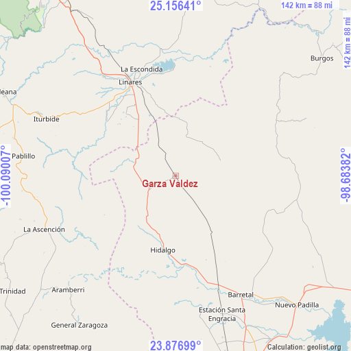
Garza Valdez GPS coordinates[2]
24° 31' 5.988" North, 99° 23' 12.984" West
| Map corner | latitude | longitude |
|---|---|---|
| Upper-left | 25.15641°, | -100.09007° |
| Center: | 24.51833°, | -99.38694° |
| Lower-right: | 23.87699°, | -98.68382° |
| Map W x H: | 142.3×142.3 km | = 88.4×88.4mi |
| max Lat: | 32.7° ⇑9.1% North |
| Garza Valdez: | 24.51833° |
| min Lat: | ⇓90.9% South 14.53588° |
| min Long | Garza Valdez | max Long |
| -117.105° | -99.38694° | -86.73105° |
| W 44.6%⇐ | ⇒55.4% E |
Elevation
Elevation of Garza Valdez is 318 m = 1043 ft, and this is 935.7 m = 3070 ft below average elevation for this country.
| Max E: |
3497 m = 11473 ft | 72.3% |
| Avg. | 1253.7 m = 4113 ft | |
| Garza Valdez | 318 m = 1043 ft | |
Min E: |
-1 m = -3 ft | 27.7% |
See also: Mexico elevation on elevation.city.
Geographical zone
Garza Valdez is located in North temperate zone (between Tropic of Cancer and the Arctic Circle). Distance of this Northern Tropic circle is 120.3 km =74.8 mi to South.| Distance of | km | miles | from Garza Valdez |
|---|---|---|---|
| North Pole | 7280.9 | 4524.1 | to North |
| Arctic Circle | 4675 | 2904.9 | to North |
| Tropic Cancer | 120.3 | 74.8 | to South |
| Equator | 2726.2 | 1694 | to South |


Nearby cities:
15 places around Garza Valdez: (largest is in red/bold)
• Barretal
55.2 km =34.3 mi,  151°
151°
• Cruz y Cruz
50.9 km =31.6 mi,  156°
156°
• El Barranco Azul
30.5 km =19 mi,  115°
115°
• El Saucillo
23.6 km =14.7 mi,  93°
93°
• General Lucio Blanco
23.9 km =14.9 mi,  356°
356°
• Guadalupe
42.6 km =26.5 mi,  348°
348°
• Hidalgo
30.5 km =19 mi,  189°
189°
• Hualahuises
49.9 km =31 mi,  324°
324°
• La Escondida
45.3 km =28.1 mi,  342°
342°
• Linares
41.9 km =26 mi,  334°
334°
• Oyama
45.3 km =28.1 mi, 163°
• Río Verde
45.4 km =28.2 mi, 339°
• San Carlos
45.5 km =28.3 mi,  81°
81°
• Villa Mainero
23.6 km =14.7 mi,  281°
281°
• Villagrán
11.7 km =7.3 mi,  244°
244°
Sources, notices
• [Note1] Compared only with cities in Mexico existing in our database
• [Src1] Map data: © OpenStreetMap contributors (CC-BY-SA)
• [Src2] Other city data from geonames.org with taken over terms of usage.
• [Src3] Geographical zone / Annual Mean Temperature by Robert A. Rohde @ Wikipedia
