Villagrán geodata
Villagrán (Tamaulipas) is a seat of a second-order administrative division; located in Mexico in America/Monterrey (GMT-6) time zone. With population of 1,343 people, there are 6476 cities with bigger population in this country. Compared to other cities in Mexico, 90.8% of cities are located further ↓South; 56.9% of cities are located further →East and 70.7% of cities have higher elevation than Villagrán. Note1


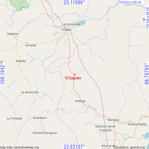
Villagrán GPS coordinates[2]
24° 28' 21.504" North, 99° 29' 27.852" West
| Map corner | latitude | longitude |
|---|---|---|
| Upper-left | 25.11096°, | -100.1942° |
| Center: | 24.47264°, | -99.49107° |
| Lower-right: | 23.83107°, | -98.78795° |
| Map W x H: | 142.3×142.3 km | = 88.4×88.4mi |
| max Lat: | 32.7° ⇑9.2% North |
| Villagrán: | 24.47264° |
| min Lat: | ⇓90.8% South 14.53588° |
| min Long | Villagrán | max Long |
| -117.105° | -99.49107° | -86.73105° |
| W 43.1%⇐ | ⇒56.9% E |
Elevation
Elevation of Villagrán is 385 m = 1263 ft, and this is 868.7 m = 2850 ft below average elevation for this country.
| Max E: |
3497 m = 11473 ft | 70.7% |
| Avg. | 1253.7 m = 4113 ft | |
| Villagrán | 385 m = 1263 ft | |
Min E: |
-1 m = -3 ft | 29.3% |
See also: Mexico elevation on elevation.city.
Geographical zone
Villagrán is located in North temperate zone (between Tropic of Cancer and the Arctic Circle). Distance of this Northern Tropic circle is 115.2 km =71.6 mi to South.| Distance of | km | miles | from Villagrán |
|---|---|---|---|
| North Pole | 7286 | 4527.3 | to North |
| Arctic Circle | 4680.1 | 2908.1 | to North |
| Tropic Cancer | 115.2 | 71.6 | to South |
| Equator | 2721.1 | 1690.8 | to South |


Nearby cities:
15 places around Villagrán: (largest is in red/bold)
• Cruz y Cruz
51.8 km =32.2 mi,  143°
143°
• El Barranco Azul
38.9 km =24.2 mi,  102°
102°
• El Saucillo
34.3 km =21.3 mi,  83°
83°
• Garza Valdez
11.7 km =7.3 mi,  64°
64°
• General Lucio Blanco
30.3 km =18.8 mi,  17°
17°
• Guadalupe
46.9 km =29.1 mi,  2°
2°
• Hidalgo
25.5 km =15.8 mi,  168°
168°
• Hualahuises
49.3 km =30.6 mi,  337°
337°
• Iturbide
50.4 km =31.3 mi,  304°
304°
• La Ascensión
45.9 km =28.5 mi,  248°
248°
• La Escondida
48.5 km =30.1 mi,  356°
356°
• Linares
43.5 km =27 mi,  349°
349°
• Oyama
44.9 km =27.9 mi,  148°
148°
• Río Verde
47.9 km =29.8 mi, 353°
• Villa Mainero
15.9 km =9.9 mi,  307°
307°
Sources, notices
• [Note1] Compared only with cities in Mexico existing in our database
• [Src1] Map data: © OpenStreetMap contributors (CC-BY-SA)
• [Src2] Other city data from geonames.org with taken over terms of usage.
• [Src3] Geographical zone / Annual Mean Temperature by Robert A. Rohde @ Wikipedia
