San Antonio Ocotlán geodata
San Antonio Ocotlán (Oaxaca) is a populated place; located in Mexico in America/Mexico_City (GMT-6) time zone. With population of 1,090 people, there are 7984 cities with bigger population in this country. Compared to other cities in Mexico, 93.3% of cities are located further ↑North; 61.7% of cities are located further ←West and 64.4% of cities have higher elevation than San Antonio Ocotlán. Note1


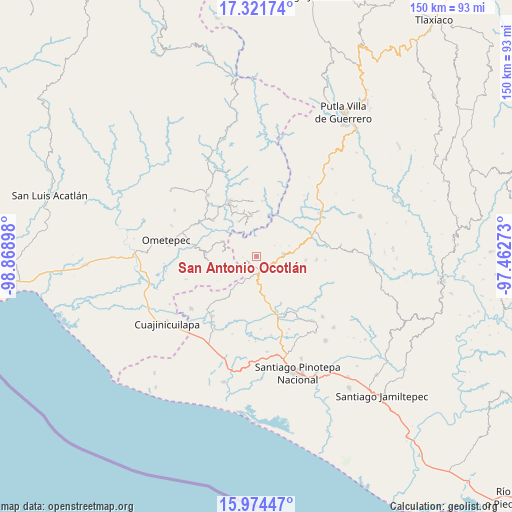
San Antonio Ocotlán GPS coordinates[2]
16° 38' 57.444" North, 98° 9' 57.06" West
| Map corner | latitude | longitude |
|---|---|---|
| Upper-left | 17.32174°, | -98.86898° |
| Center: | 16.64929°, | -98.16585° |
| Lower-right: | 15.97447°, | -97.46273° |
| Map W x H: | 149.8×149.8 km | = 93.1×93.1mi |
| max Lat: | 32.7° ⇑93.3% North |
| San Antonio Ocotlán: | 16.64929° |
| min Lat: | ⇓6.7% South 14.53588° |
| min Long | San Antonio Oco | max Long |
| -117.105° | -98.16585° | -86.73105° |
| W 61.7%⇐ | ⇒38.3% E |
Elevation
Elevation of San Antonio Ocotlán is 719 m = 2359 ft, and this is 534.7 m = 1754 ft below average elevation for this country.
| Max E: |
3497 m = 11473 ft | 64.4% |
| Avg. | 1253.7 m = 4113 ft | |
| San Antonio Ocotlán | 719 m = 2359 ft | |
Min E: |
-1 m = -3 ft | 35.6% |
See also: Mexico elevation on elevation.city.
Geographical zone
San Antonio Ocotlán is located in North Torrid zone (between Equator and Tropic of Cancer). Distance of this Northern Tropic circle is 754.7 km =468.9 mi to North.| Distance of | km | miles | from San Antonio Ocotlán |
|---|---|---|---|
| North Pole | 8155.8 | 5067.8 | to North |
| Arctic Circle | 5549.9 | 3448.5 | to North |
| Tropic Cancer | 754.7 | 468.9 | to North |
| Equator | 1851.2 | 1150.3 | to South |


Nearby cities:
15 places around San Antonio Ocotlán: (largest is in red/bold)
• Arroyo Gente
9.6 km =6 mi,  339°
339°
• Buenavista
3.2 km =2 mi,  243°
243°
• Camotinchan
11 km =6.8 mi,  156°
156°
• Guadalupe Victoria
12 km =7.5 mi,  351°
351°
• Huajintepec
8.1 km =5 mi, 237°
• La Concepción
10 km =6.2 mi,  277°
277°
• La Guadalupe
9.9 km =6.2 mi,  72°
72°
• La Guadalupe
11.2 km =7 mi,  293°
293°
• Los Liros
11.4 km =7.1 mi,  331°
331°
• Pie de la Cuesta
5.2 km =3.2 mi,  126°
126°
• San Juan Cacahuatepec
3.9 km =2.4 mi, 162°
• San Pedro Amuzgos
7.9 km =4.9 mi,  86°
86°
• San Sebastián Ixcapa
11.8 km =7.3 mi,  168°
168°
• Sayultepec
7.1 km =4.4 mi,  147°
147°
• Vista Hermosa
12.7 km =7.9 mi,  184°
184°
Sources, notices
• [Note1] Compared only with cities in Mexico existing in our database
• [Src1] Map data: © OpenStreetMap contributors (CC-BY-SA)
• [Src2] Other city data from geonames.org with taken over terms of usage.
• [Src3] Geographical zone / Annual Mean Temperature by Robert A. Rohde @ Wikipedia
