La Guadalupe geodata
La Guadalupe (Guerrero) is a populated place; located in Mexico in America/Mexico_City (GMT-6) time zone. With population of 1,147 people, there are 7562 cities with bigger population in this country. Compared to other cities in Mexico, 92.9% of cities are located further ↑North; 60.4% of cities are located further ←West and 69.7% of cities have higher elevation than La Guadalupe. Note1


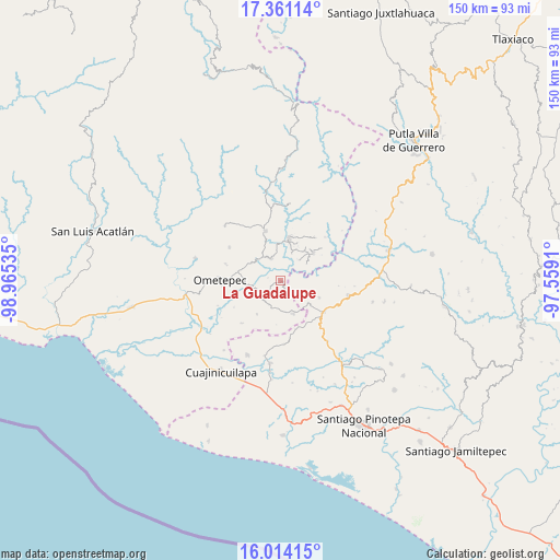
La Guadalupe GPS coordinates[2]
16° 41' 19.788" North, 98° 15' 43.992" West
| Map corner | latitude | longitude |
|---|---|---|
| Upper-left | 17.36114°, | -98.96535° |
| Center: | 16.68883°, | -98.26222° |
| Lower-right: | 16.01415°, | -97.5591° |
| Map W x H: | 149.8×149.8 km | = 93.1×93.1mi |
| max Lat: | 32.7° ⇑92.9% North |
| La Guadalupe: | 16.68883° |
| min Lat: | ⇓7.1% South 14.53588° |
| min Long | La Guadalupe | max Long |
| -117.105° | -98.26222° | -86.73105° |
| W 60.4%⇐ | ⇒39.6% E |
Elevation
Elevation of La Guadalupe is 432 m = 1417 ft, and this is 821.7 m = 2696 ft below average elevation for this country.
| Max E: |
3497 m = 11473 ft | 69.7% |
| Avg. | 1253.7 m = 4113 ft | |
| La Guadalupe | 432 m = 1417 ft | |
Min E: |
-1 m = -3 ft | 30.3% |
See also: Mexico elevation on elevation.city.
Geographical zone
La Guadalupe is located in North Torrid zone (between Equator and Tropic of Cancer). Distance of this Northern Tropic circle is 750.3 km =466.2 mi to North.| Distance of | km | miles | from La Guadalupe |
|---|---|---|---|
| North Pole | 8151.4 | 5065 | to North |
| Arctic Circle | 5545.6 | 3445.9 | to North |
| Tropic Cancer | 750.3 | 466.2 | to North |
| Equator | 1855.6 | 1153 | to South |


Nearby cities:
15 places around La Guadalupe: (largest is in red/bold)
• Arroyo Gente
8.2 km =5.1 mi,  56°
56°
• Buenavista
9.4 km =5.8 mi,  128°
128°
• Cruz Verde II
3.6 km =2.2 mi,  286°
286°
• Cumbre de Barranca Honda
9.2 km =5.7 mi,  300°
300°
• El Santiago
10 km =6.2 mi,  37°
37°
• Guadalupe Victoria
11.4 km =7.1 mi,  48°
48°
• Huajintepec
9.4 km =5.8 mi,  158°
158°
• Huixtepec
6 km =3.7 mi,  229°
229°
• La Concepción
3.1 km =1.9 mi,  174°
174°
• Los Liros
7.4 km =4.6 mi, 40°
• Plan de Pierna
11.5 km =7.1 mi,  34°
34°
• Plan de los Muertos
8 km =5 mi,  21°
21°
• San Antonio Ocotlán
11.2 km =7 mi,  113°
113°
• Tierra Blanca
10.8 km =6.7 mi,  216°
216°
• Zacoalpan
6.8 km =4.2 mi,  336°
336°
Sources, notices
• [Note1] Compared only with cities in Mexico existing in our database
• [Src1] Map data: © OpenStreetMap contributors (CC-BY-SA)
• [Src2] Other city data from geonames.org with taken over terms of usage.
• [Src3] Geographical zone / Annual Mean Temperature by Robert A. Rohde @ Wikipedia
