Huajintepec geodata
Huajintepec (Oaxaca) is a populated place; located in Mexico in America/Mexico_City (GMT-6) time zone. With population of 2,567 people, there are 3448 cities with bigger population in this country. Compared to other cities in Mexico, 93.5% of cities are located further ↑North; 60.8% of cities are located further ←West and 71.8% of cities have higher elevation than Huajintepec. Note1


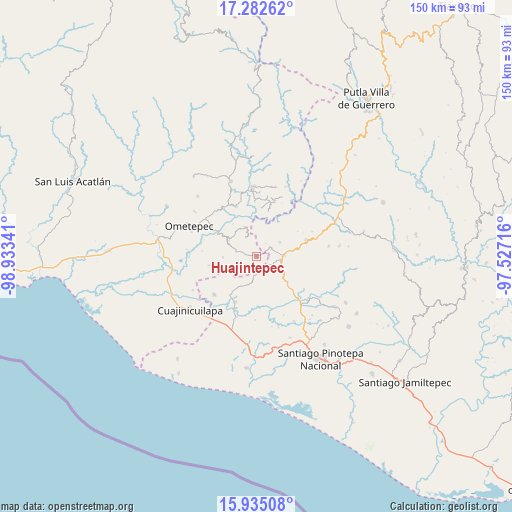
Huajintepec GPS coordinates[2]
16° 36' 36.108" North, 98° 13' 49.008" West
| Map corner | latitude | longitude |
|---|---|---|
| Upper-left | 17.28262°, | -98.93341° |
| Center: | 16.61003°, | -98.23028° |
| Lower-right: | 15.93508°, | -97.52716° |
| Map W x H: | 149.8×149.8 km | = 93.1×93.1mi |
| max Lat: | 32.7° ⇑93.5% North |
| Huajintepec: | 16.61003° |
| min Lat: | ⇓6.5% South 14.53588° |
| min Long | Huajintepec | max Long |
| -117.105° | -98.23028° | -86.73105° |
| W 60.8%⇐ | ⇒39.2% E |
Elevation
Elevation of Huajintepec is 333 m = 1093 ft, and this is 920.7 m = 3021 ft below average elevation for this country.
| Max E: |
3497 m = 11473 ft | 71.8% |
| Avg. | 1253.7 m = 4113 ft | |
| Huajintepec | 333 m = 1093 ft | |
Min E: |
-1 m = -3 ft | 28.2% |
See also: Mexico elevation on elevation.city.
Geographical zone
Huajintepec is located in North Torrid zone (between Equator and Tropic of Cancer). Distance of this Northern Tropic circle is 759.1 km =471.7 mi to North.| Distance of | km | miles | from Huajintepec |
|---|---|---|---|
| North Pole | 8160.2 | 5070.5 | to North |
| Arctic Circle | 5554.3 | 3451.3 | to North |
| Tropic Cancer | 759.1 | 471.7 | to North |
| Equator | 1846.9 | 1147.6 | to South |


Nearby cities:
15 places around Huajintepec: (largest is in red/bold)
• Buenavista
4.9 km =3 mi,  53°
53°
• Camotinchan
12.6 km =7.8 mi,  116°
116°
• Cruz Verde II
11.9 km =7.4 mi,  325°
325°
• Huixtepec
9.3 km =5.8 mi,  301°
301°
• La Concepción
6.4 km =4 mi, 331°
• La Guadalupe
9.4 km =5.8 mi,  338°
338°
• Mártires de Tacubaya
8.4 km =5.2 mi,  197°
197°
• Pie de la Cuesta
11.1 km =6.9 mi,  83°
83°
• San Antonio Ocotlán
8.1 km =5 mi,  57°
57°
• San Francisco del Maguey
13.6 km =8.5 mi,  215°
215°
• San Juan Cacahuatepec
8 km =5 mi,  85°
85°
• San Sebastián Ixcapa
11.6 km =7.2 mi,  128°
128°
• Sayultepec
10.8 km =6.7 mi,  98°
98°
• Tierra Blanca
9.8 km =6.1 mi,  270°
270°
• Vista Hermosa
10.1 km =6.3 mi,  145°
145°
Sources, notices
• [Note1] Compared only with cities in Mexico existing in our database
• [Src1] Map data: © OpenStreetMap contributors (CC-BY-SA)
• [Src2] Other city data from geonames.org with taken over terms of usage.
• [Src3] Geographical zone / Annual Mean Temperature by Robert A. Rohde @ Wikipedia
