San Andrés Tepetitlán geodata
San Andrés Tepetitlán (State of Mexico) is a populated place; located in Mexico in America/Mexico_City (GMT-6) time zone. With population of 1,760 people, there are 4933 cities with bigger population in this country. Compared to other cities in Mexico, 67.1% of cities are located further ↑North; 62.9% of cities are located further →East and 85.5% of cities have lower elevation than San Andrés Tepetitlán. Note1


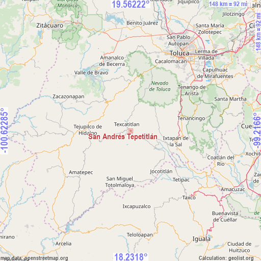
San Andrés Tepetitlán GPS coordinates[2]
18° 53' 53.988" North, 99° 55' 10.992" West
| Map corner | latitude | longitude |
|---|---|---|
| Upper-left | 19.56222°, | -100.62285° |
| Center: | 18.89833°, | -99.91972° |
| Lower-right: | 18.2318°, | -99.2166° |
| Map W x H: | 147.9×147.9 km | = 91.9×91.9mi |
| max Lat: | 32.7° ⇑67.1% North |
| San Andrés Tepetitlán: | 18.89833° |
| min Lat: | ⇓32.9% South 14.53588° |
| min Long | San Andrés Tep | max Long |
| -117.105° | -99.91972° | -86.73105° |
| W 37.1%⇐ | ⇒62.9% E |
Elevation
Elevation of San Andrés Tepetitlán is 2269 m = 7444 ft, and this is 1015.3 m = 3331 ft above average elevation for this country.
| Max E: |
3497 m = 11473 ft | 14.5% |
| San Andrés Tepetitlán | 2269 m 7444 ft | |
| Avg. | 1253.7 m = 4113 ft | |
Min E: |
-1 m = -3 ft | 85.5% |
See also: Mexico elevation on elevation.city.
Geographical zone
San Andrés Tepetitlán is located in North Torrid zone (between Equator and Tropic of Cancer). Distance of this Northern Tropic circle is 504.6 km =313.5 mi to North.| Distance of | km | miles | from San Andrés Tepetitlán |
|---|---|---|---|
| North Pole | 7905.8 | 4912.4 | to North |
| Arctic Circle | 5299.9 | 3293.2 | to North |
| Tropic Cancer | 504.6 | 313.5 | to North |
| Equator | 2101.3 | 1305.7 | to South |


Nearby cities:
15 places around San Andrés Tepetitlán: (largest is in red/bold)
• Acatitlán
4.2 km =2.6 mi,  310°
310°
• Agua Fría
6.2 km =3.9 mi,  130°
130°
• Almoloya de Alquisiras
4.5 km =2.8 mi,  143°
143°
• Capula
5.3 km =3.3 mi,  234°
234°
• Cuauhtenco
6.1 km =3.8 mi, 141°
• Diego Sánchez
8.4 km =5.2 mi,  203°
203°
• El Chapaneal
6.5 km =4 mi,  327°
327°
• Hueyatenco
5.2 km =3.2 mi,  257°
257°
• Las Vueltas
6.7 km =4.2 mi,  85°
85°
• Palmillas
8.5 km =5.3 mi,  25°
25°
• San Agustín
5.3 km =3.3 mi,  337°
337°
• San Francisco
1.5 km =0.9 mi,  316°
316°
• Sultepec
6.6 km =4.1 mi, 227°
• Texcaltitlán
4.1 km =2.5 mi, 330°
• Texcapilla
5.9 km =3.7 mi, 25°
Sources, notices
• [Note1] Compared only with cities in Mexico existing in our database
• [Src1] Map data: © OpenStreetMap contributors (CC-BY-SA)
• [Src2] Other city data from geonames.org with taken over terms of usage.
• [Src3] Geographical zone / Annual Mean Temperature by Robert A. Rohde @ Wikipedia
