Sultepec geodata
Sultepec (State of Mexico) is a seat of a second-order administrative division; located in Mexico in America/Mexico_City (GMT-6) time zone. With population of 3,595 people, there are 2546 cities with bigger population in this country. Compared to other cities in Mexico, 67.8% of cities are located further ↑North; 63.6% of cities are located further →East and 87.2% of cities have lower elevation than Sultepec. Note1


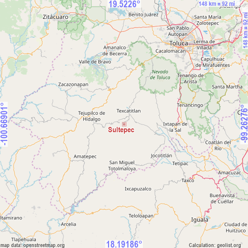
Sultepec GPS coordinates[2]
18° 51' 30.78" North, 99° 57' 57.168" West
| Map corner | latitude | longitude |
|---|---|---|
| Upper-left | 19.5226°, | -100.66901° |
| Center: | 18.85855°, | -99.96588° |
| Lower-right: | 18.19186°, | -99.26276° |
| Map W x H: | 148×148 km | = 92×92mi |
| max Lat: | 32.7° ⇑67.8% North |
| Sultepec: | 18.85855° |
| min Lat: | ⇓32.2% South 14.53588° |
| min Long | Sultepec | max Long |
| -117.105° | -99.96588° | -86.73105° |
| W 36.4%⇐ | ⇒63.6% E |
Elevation
Elevation of Sultepec is 2314 m = 7592 ft, and this is 1060.3 m = 3479 ft above average elevation for this country.
| Max E: |
3497 m = 11473 ft | 12.8% |
| Sultepec | 2314 m 7592 ft | |
| Avg. | 1253.7 m = 4113 ft | |
Min E: |
-1 m = -3 ft | 87.2% |
See also: Mexico elevation on elevation.city.
Geographical zone
Sultepec is located in North Torrid zone (between Equator and Tropic of Cancer). Distance of this Northern Tropic circle is 509 km =316.3 mi to North.| Distance of | km | miles | from Sultepec |
|---|---|---|---|
| North Pole | 7910.2 | 4915.2 | to North |
| Arctic Circle | 5304.3 | 3295.9 | to North |
| Tropic Cancer | 509 | 316.3 | to North |
| Equator | 2096.9 | 1303 | to South |


Nearby cities:
15 places around Sultepec: (largest is in red/bold)
• Acatitlán
7.3 km =4.5 mi,  12°
12°
• Agua Fría
9.5 km =5.9 mi,  87°
87°
• Almoloya de Alquisiras
7.5 km =4.7 mi,  84°
84°
• Capula
1.4 km =0.9 mi,  22°
22°
• Cuauhtenco
8.6 km =5.3 mi, 92°
• Diego Sánchez
3.6 km =2.2 mi,  154°
154°
• Hueyatenco
3.3 km =2.1 mi,  356°
356°
• Pantoja
5.8 km =3.6 mi,  290°
290°
• San Agustín
9.7 km =6 mi, 16°
• San Andrés Ocotepec
9.9 km =6.2 mi,  300°
300°
• San Andrés Tepetitlán
6.6 km =4.1 mi,  47°
47°
• San Francisco
6.7 km =4.2 mi,  35°
35°
• San Isidro Xochitla
9.1 km =5.7 mi,  217°
217°
• Santa Cruz
3.4 km =2.1 mi,  213°
213°
• Texcaltitlán
8.5 km =5.3 mi, 19°
Sources, notices
• [Note1] Compared only with cities in Mexico existing in our database
• [Src1] Map data: © OpenStreetMap contributors (CC-BY-SA)
• [Src2] Other city data from geonames.org with taken over terms of usage.
• [Src3] Geographical zone / Annual Mean Temperature by Robert A. Rohde @ Wikipedia
