Capula geodata
Capula (State of Mexico) is a populated place; located in Mexico in America/Mexico_City (GMT-6) time zone. With population of 1,032 people, there are 8443 cities with bigger population in this country. Compared to other cities in Mexico, 67.7% of cities are located further ↑North; 63.5% of cities are located further →East and 88.8% of cities have lower elevation than Capula. Note1


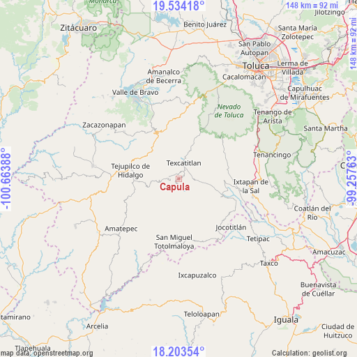
Capula GPS coordinates[2]
18° 52' 12.648" North, 99° 57' 38.7" West
| Map corner | latitude | longitude |
|---|---|---|
| Upper-left | 19.53418°, | -100.66388° |
| Center: | 18.87018°, | -99.96075° |
| Lower-right: | 18.20354°, | -99.25763° |
| Map W x H: | 148×148 km | = 92×92mi |
| max Lat: | 32.7° ⇑67.7% North |
| Capula: | 18.87018° |
| min Lat: | ⇓32.3% South 14.53588° |
| min Long | Capula | max Long |
| -117.105° | -99.96075° | -86.73105° |
| W 36.5%⇐ | ⇒63.5% E |
Elevation
Elevation of Capula is 2366 m = 7762 ft, and this is 1112.3 m = 3649 ft above average elevation for this country.
| Max E: |
3497 m = 11473 ft | 11.2% |
| Capula | 2366 m 7762 ft | |
| Avg. | 1253.7 m = 4113 ft | |
Min E: |
-1 m = -3 ft | 88.8% |
See also: Mexico elevation on elevation.city.
Geographical zone
Capula is located in North Torrid zone (between Equator and Tropic of Cancer). Distance of this Northern Tropic circle is 507.8 km =315.5 mi to North.| Distance of | km | miles | from Capula |
|---|---|---|---|
| North Pole | 7908.9 | 4914.4 | to North |
| Arctic Circle | 5303 | 3295.1 | to North |
| Tropic Cancer | 507.8 | 315.5 | to North |
| Equator | 2098.2 | 1303.8 | to South |


Nearby cities:
15 places around Capula: (largest is in red/bold)
• Acatitlán
6 km =3.7 mi,  10°
10°
• Agua Fría
9 km =5.6 mi,  95°
95°
• Almoloya de Alquisiras
7 km =4.3 mi,  94°
94°
• Cuauhtenco
8.2 km =5.1 mi, 101°
• Diego Sánchez
4.7 km =2.9 mi,  167°
167°
• El Chapaneal
8.7 km =5.4 mi, 5°
• Hueyatenco
2.2 km =1.4 mi,  339°
339°
• Pantoja
6.1 km =3.8 mi,  276°
276°
• San Agustín
8.3 km =5.2 mi,  15°
15°
• San Andrés Ocotepec
9.8 km =6.1 mi,  292°
292°
• San Andrés Tepetitlán
5.3 km =3.3 mi,  54°
54°
• San Francisco
5.3 km =3.3 mi,  38°
38°
• Santa Cruz
4.7 km =2.9 mi,  210°
210°
• Sultepec
1.4 km =0.9 mi,  202°
202°
• Texcaltitlán
7.1 km =4.4 mi, 19°
Sources, notices
• [Note1] Compared only with cities in Mexico existing in our database
• [Src1] Map data: © OpenStreetMap contributors (CC-BY-SA)
• [Src2] Other city data from geonames.org with taken over terms of usage.
• [Src3] Geographical zone / Annual Mean Temperature by Robert A. Rohde @ Wikipedia
