San Andrés Sinaxtla geodata
San Andrés Sinaxtla (Oaxaca) is a seat of a second-order administrative division; located in Mexico in America/Mexico_City (GMT-6) time zone. With population of 580 people, there are 14779 cities with bigger population in this country. Compared to other cities in Mexico, 83.4% of cities are located further ↑North; 71.6% of cities are located further ←West and 78.5% of cities have lower elevation than San Andrés Sinaxtla. Note1


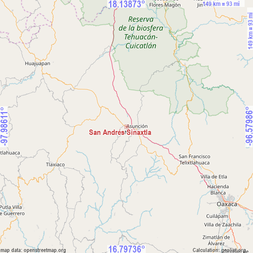
San Andrés Sinaxtla GPS coordinates[2]
17° 28' 9.408" North, 97° 16' 58.728" West
| Map corner | latitude | longitude |
|---|---|---|
| Upper-left | 18.13873°, | -97.98611° |
| Center: | 17.46928°, | -97.28298° |
| Lower-right: | 16.79736°, | -96.57986° |
| Map W x H: | 149.1×149.1 km | = 92.6×92.6mi |
| max Lat: | 32.7° ⇑83.4% North |
| San Andrés Sinaxtla: | 17.46928° |
| min Lat: | ⇓16.6% South 14.53588° |
| min Long | San Andrés Sin | max Long |
| -117.105° | -97.28298° | -86.73105° |
| W 71.6%⇐ | ⇒28.4% E |
Elevation
Elevation of San Andrés Sinaxtla is 2099 m = 6886 ft, and this is 845.3 m = 2773 ft above average elevation for this country.
| Max E: |
3497 m = 11473 ft | 21.5% |
| San Andrés Sinaxtla | 2099 m 6886 ft | |
| Avg. | 1253.7 m = 4113 ft | |
Min E: |
-1 m = -3 ft | 78.5% |
See also: Mexico elevation on elevation.city.
Geographical zone
San Andrés Sinaxtla is located in North Torrid zone (between Equator and Tropic of Cancer). Distance of this Northern Tropic circle is 663.5 km =412.3 mi to North.| Distance of | km | miles | from San Andrés Sinaxtla |
|---|---|---|---|
| North Pole | 8064.7 | 5011.2 | to North |
| Arctic Circle | 5458.8 | 3391.9 | to North |
| Tropic Cancer | 663.5 | 412.3 | to North |
| Equator | 1942.4 | 1207 | to South |


Nearby cities:
15 places around San Andrés Sinaxtla: (largest is in red/bold)
• Asunción Nochixtlán
6.1 km =3.8 mi,  100°
100°
• Magdalena Zahuatlán
10.6 km =6.6 mi,  146°
146°
• San Francisco Chindúa
5.6 km =3.5 mi,  214°
214°
• San Francisco Jaltepetongo
9.5 km =5.9 mi,  168°
168°
• San Francisco Nuxaño
11.6 km =7.2 mi, 213°
• San Juan Sayultepec
1.8 km =1.1 mi,  186°
186°
• San Mateo Etlatongo
6 km =3.7 mi, 170°
• San Miguel Tecomatlán
8.5 km =5.3 mi, 169°
• San Pedro Topiltepec
7.4 km =4.6 mi,  240°
240°
• Santa María Chachoápam
6.3 km =3.9 mi,  358°
358°
• Santiago Nejapilla
11.1 km =6.9 mi, 240°
• Santiago Tillo
4.1 km =2.5 mi,  256°
256°
• Santo Domingo Tlatayapam
9.5 km =5.9 mi,  224°
224°
• Santo Domingo Yanhuitlán
9.1 km =5.7 mi,  316°
316°
• Yucuita
4.8 km =3 mi,  17°
17°
Sources, notices
• [Note1] Compared only with cities in Mexico existing in our database
• [Src1] Map data: © OpenStreetMap contributors (CC-BY-SA)
• [Src2] Other city data from geonames.org with taken over terms of usage.
• [Src3] Geographical zone / Annual Mean Temperature by Robert A. Rohde @ Wikipedia
