Yucuita geodata
Yucuita (Oaxaca) is a seat of a second-order administrative division; located in Mexico in America/Mexico_City (GMT-6) time zone. With population of 517 people, there are 16282 cities with bigger population in this country. Compared to other cities in Mexico, 83% of cities are located further ↑North; 71.8% of cities are located further ←West and 77.7% of cities have lower elevation than Yucuita. Note1


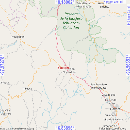
Yucuita GPS coordinates[2]
17° 30' 38.628" North, 97° 16' 10.74" West
| Map corner | latitude | longitude |
|---|---|---|
| Upper-left | 18.18002°, | -97.97278° |
| Center: | 17.51073°, | -97.26965° |
| Lower-right: | 16.83896°, | -96.56653° |
| Map W x H: | 149.1×149.1 km | = 92.6×92.6mi |
| max Lat: | 32.7° ⇑83% North |
| Yucuita: | 17.51073° |
| min Lat: | ⇓17% South 14.53588° |
| min Long | Yucuita | max Long |
| -117.105° | -97.26965° | -86.73105° |
| W 71.8%⇐ | ⇒28.2% E |
Elevation
Elevation of Yucuita is 2081 m = 6827 ft, and this is 827.3 m = 2714 ft above average elevation for this country.
| Max E: |
3497 m = 11473 ft | 22.3% |
| Yucuita | 2081 m 6827 ft | |
| Avg. | 1253.7 m = 4113 ft | |
Min E: |
-1 m = -3 ft | 77.7% |
See also: Mexico elevation on elevation.city.
Geographical zone
Yucuita is located in North Torrid zone (between Equator and Tropic of Cancer). Distance of this Northern Tropic circle is 658.9 km =409.4 mi to North.| Distance of | km | miles | from Yucuita |
|---|---|---|---|
| North Pole | 8060.1 | 5008.3 | to North |
| Arctic Circle | 5454.2 | 3389.1 | to North |
| Tropic Cancer | 658.9 | 409.4 | to North |
| Equator | 1947 | 1209.8 | to South |


Nearby cities:
15 places around Yucuita: (largest is in red/bold)
• Asunción Nochixtlán
7.4 km =4.6 mi,  141°
141°
• El Fortín Alto
13.4 km =8.3 mi,  34°
34°
• San Andrés Sinaxtla
4.8 km =3 mi,  197°
197°
• San Francisco Chindúa
10.3 km =6.4 mi,  206°
206°
• San Francisco Jaltepetongo
13.9 km =8.6 mi,  177°
177°
• San Juan Sayultepec
6.6 km =4.1 mi,  194°
194°
• San Mateo Etlatongo
10.5 km =6.5 mi, 182°
• San Miguel Tecomatlán
12.9 km =8 mi, 179°
• San Pedro Coxcaltepec Cántaros
14 km =8.7 mi,  95°
95°
• San Pedro Topiltepec
11.4 km =7.1 mi,  223°
223°
• Santa María Chachoápam
2.3 km =1.4 mi,  317°
317°
• Santiago Tillo
7.7 km =4.8 mi, 224°
• Santo Domingo Tlatayapam
14 km =8.7 mi, 215°
• Santo Domingo Yanhuitlán
8 km =5 mi,  284°
284°
• Soyaltepec
9.9 km =6.2 mi,  335°
335°
Sources, notices
• [Note1] Compared only with cities in Mexico existing in our database
• [Src1] Map data: © OpenStreetMap contributors (CC-BY-SA)
• [Src2] Other city data from geonames.org with taken over terms of usage.
• [Src3] Geographical zone / Annual Mean Temperature by Robert A. Rohde @ Wikipedia
