Santo Domingo Yanhuitlán geodata
Santo Domingo Yanhuitlán (Oaxaca) is a populated place; located in Mexico in America/Mexico_City (GMT-6) time zone. With population of 1,002 people, there are 8703 cities with bigger population in this country. Compared to other cities in Mexico, 82.8% of cities are located further ↑North; 71.1% of cities are located further ←West and 80.5% of cities have lower elevation than Santo Domingo Yanhuitlán. Note1
Current local time in Santo Domingo Yanhuitlán:
11:19 AM, MondayDifference from your time zone: hours


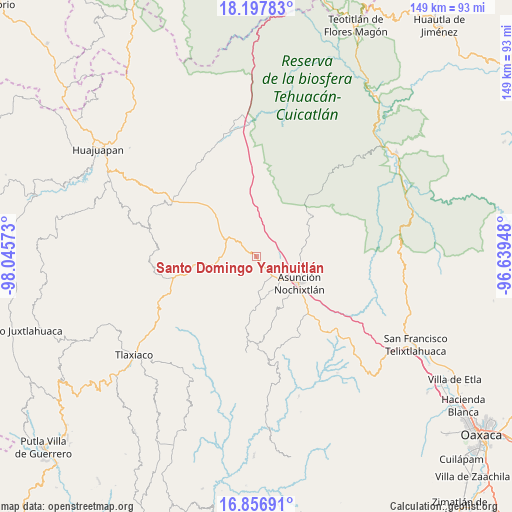
Santo Domingo Yanhuitlán GPS coordinates[2]
17° 31' 42.996" North, 97° 20' 33.36" West
| Map corner | latitude | longitude |
|---|---|---|
| Upper-left | 18.19783°, | -98.04573° |
| Center: | 17.52861°, | -97.3426° |
| Lower-right: | 16.85691°, | -96.63948° |
| Map W x H: | 149.1×149.1 km | = 92.6×92.6mi |
| max Lat: | 32.7° ⇑82.8% North |
| Santo Domingo Yanhuitlán: | 17.52861° |
| min Lat: | ⇓17.2% South 14.53588° |
| min Long | Santo Domingo Y | max Long |
| -117.105° | -97.3426° | -86.73105° |
| W 71.1%⇐ | ⇒28.9% E |
Elevation
Elevation of Santo Domingo Yanhuitlán is 2154 m = 7067 ft, and this is 900.3 m = 2954 ft above average elevation for this country.
| Max E: |
3497 m = 11473 ft | 19.5% |
| Santo Domingo Yanhuitlán | 2154 m 7067 ft | |
| Avg. | 1253.7 m = 4113 ft | |
Min E: |
-1 m = -3 ft | 80.5% |
See also: Mexico elevation on elevation.city.
Geographical zone
Santo Domingo Yanhuitlán is located in North Torrid zone (between Equator and Tropic of Cancer). Distance of this Northern Tropic circle is 656.9 km =408.2 mi to North.| Distance of | km | miles | from Santo Domingo Yanhuitlán |
|---|---|---|---|
| North Pole | 8058.1 | 5007.1 | to North |
| Arctic Circle | 5452.2 | 3387.8 | to North |
| Tropic Cancer | 656.9 | 408.2 | to North |
| Equator | 1949 | 1211.1 | to South |


Nearby cities:
15 places around Santo Domingo Yanhuitlán: (largest is in red/bold)
• Asunción Nochixtlán
14.6 km =9.1 mi,  121°
121°
• Nativitas
14.8 km =9.2 mi,  2°
2°
• San Andrés Sinaxtla
9.1 km =5.7 mi,  136°
136°
• San Francisco Chindúa
11.6 km =7.2 mi,  164°
164°
• San Juan Sayultepec
10.4 km =6.5 mi, 143°
• San Mateo Etlatongo
14.5 km =9 mi,  149°
149°
• San Pedro Topiltepec
10.3 km =6.4 mi,  180°
180°
• San Pedro y San Pablo Teposcolula
15.5 km =9.6 mi,  262°
262°
• San Vicente Nuñu
13.3 km =8.3 mi,  233°
233°
• Santa María Chachoápam
6.2 km =3.9 mi,  92°
92°
• Santiago Nejapilla
12.5 km =7.8 mi,  195°
195°
• Santiago Tillo
7.9 km =4.9 mi, 162°
• Santo Domingo Tlatayapam
13.4 km =8.3 mi, 181°
• Soyaltepec
7.9 km =4.9 mi,  27°
27°
• Yucuita
8 km =5 mi,  104°
104°
Sources, notices
• [Note1] Compared only with cities in Mexico existing in our database
• [Src1] Map data: © OpenStreetMap contributors (CC-BY-SA)
• [Src2] Other city data from geonames.org with taken over terms of usage.
• [Src3] Geographical zone / Annual Mean Temperature by Robert A. Rohde @ Wikipedia
