El Terrero geodata
El Terrero (Guerrero) is a populated place; located in Mexico in America/Mexico_City (GMT-6) time zone. With population of 1,063 people, there are 8213 cities with bigger population in this country. Compared to other cities in Mexico, 87.5% of cities are located further ↑North; 54.9% of cities are located further →East and 71.5% of cities have higher elevation than El Terrero. Note1


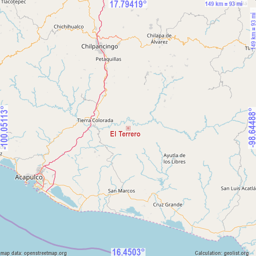
El Terrero GPS coordinates[2]
17° 7' 24.456" North, 99° 20' 52.8" West
| Map corner | latitude | longitude |
|---|---|---|
| Upper-left | 17.79419°, | -100.05113° |
| Center: | 17.12346°, | -99.348° |
| Lower-right: | 16.4503°, | -98.64488° |
| Map W x H: | 149.4×149.4 km | = 92.8×92.8mi |
| max Lat: | 32.7° ⇑87.5% North |
| El Terrero: | 17.12346° |
| min Lat: | ⇓12.5% South 14.53588° |
| min Long | El Terrero | max Long |
| -117.105° | -99.348° | -86.73105° |
| W 45.1%⇐ | ⇒54.9% E |
Elevation
Elevation of El Terrero is 348 m = 1142 ft, and this is 905.7 m = 2971 ft below average elevation for this country.
| Max E: |
3497 m = 11473 ft | 71.5% |
| Avg. | 1253.7 m = 4113 ft | |
| El Terrero | 348 m = 1142 ft | |
Min E: |
-1 m = -3 ft | 28.5% |
See also: Mexico elevation on elevation.city.
Geographical zone
El Terrero is located in North Torrid zone (between Equator and Tropic of Cancer). Distance of this Northern Tropic circle is 702 km =436.2 mi to North.| Distance of | km | miles | from El Terrero |
|---|---|---|---|
| North Pole | 8103.1 | 5035 | to North |
| Arctic Circle | 5497.2 | 3415.8 | to North |
| Tropic Cancer | 702 | 436.2 | to North |
| Equator | 1904 | 1183.1 | to South |


Nearby cities:
15 places around El Terrero: (largest is in red/bold)
• Chautipa
5.7 km =3.5 mi,  231°
231°
• El Charco
10.3 km =6.4 mi,  132°
132°
• El Limón
14.6 km =9.1 mi,  192°
192°
• El Puente
6.8 km =4.2 mi,  301°
301°
• El Tabacal
1.2 km =0.7 mi,  154°
154°
• Los Magueyitos
10.7 km =6.6 mi, 125°
• Los Tepetates
12.9 km =8 mi,  123°
123°
• Nacaxtlán
9.9 km =6.2 mi,  31°
31°
• Pochotillo
14.2 km =8.8 mi,  216°
216°
• Pueblo Viejo
13.9 km =8.6 mi, 34°
• Rancho Viejo
6.4 km =4 mi,  240°
240°
• San Francisco
14.8 km =9.2 mi, 152°
• Tlayolapa
3.1 km =1.9 mi, 295°
• Xalpatláhuac
11.3 km =7 mi,  170°
170°
• Xochitepec
14.5 km =9 mi,  63°
63°
Sources, notices
• [Note1] Compared only with cities in Mexico existing in our database
• [Src1] Map data: © OpenStreetMap contributors (CC-BY-SA)
• [Src2] Other city data from geonames.org with taken over terms of usage.
• [Src3] Geographical zone / Annual Mean Temperature by Robert A. Rohde @ Wikipedia
