El Charco geodata
El Charco (Guerrero) is a populated place; located in Mexico in America/Mexico_City (GMT-6) time zone. With population of 538 people, there are 15775 cities with bigger population in this country. Compared to other cities in Mexico, 88.1% of cities are located further ↑North; 54% of cities are located further →East and 61.9% of cities have higher elevation than El Charco. Note1


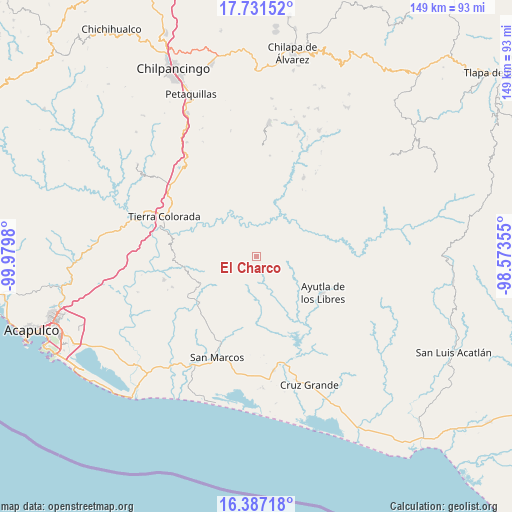
El Charco GPS coordinates[2]
17° 3' 38.016" North, 99° 16' 36.012" West
| Map corner | latitude | longitude |
|---|---|---|
| Upper-left | 17.73152°, | -99.9798° |
| Center: | 17.06056°, | -99.27667° |
| Lower-right: | 16.38718°, | -98.57355° |
| Map W x H: | 149.5×149.5 km | = 92.9×92.9mi |
| max Lat: | 32.7° ⇑88.1% North |
| El Charco: | 17.06056° |
| min Lat: | ⇓11.9% South 14.53588° |
| min Long | El Charco | max Long |
| -117.105° | -99.27667° | -86.73105° |
| W 46%⇐ | ⇒54% E |
Elevation
Elevation of El Charco is 884 m = 2900 ft, and this is 369.7 m = 1213 ft below average elevation for this country.
| Max E: |
3497 m = 11473 ft | 61.9% |
| Avg. | 1253.7 m = 4113 ft | |
| El Charco | 884 m = 2900 ft | |
Min E: |
-1 m = -3 ft | 38.1% |
See also: Mexico elevation on elevation.city.
Geographical zone
El Charco is located in North Torrid zone (between Equator and Tropic of Cancer). Distance of this Northern Tropic circle is 709 km =440.6 mi to North.| Distance of | km | miles | from El Charco |
|---|---|---|---|
| North Pole | 8110.1 | 5039.4 | to North |
| Arctic Circle | 5504.2 | 3420.2 | to North |
| Tropic Cancer | 709 | 440.6 | to North |
| Equator | 1897 | 1178.7 | to South |


Nearby cities:
15 places around El Charco: (largest is in red/bold)
• Buenavista de Allende
9.5 km =5.9 mi,  134°
134°
• Colotepec
7.1 km =4.4 mi,  107°
107°
• El Pericón
10.4 km =6.5 mi,  210°
210°
• El Refugio
8.5 km =5.3 mi, 106°
• El Tabacal
9.2 km =5.7 mi,  309°
309°
• El Terrero
10.3 km =6.4 mi, 312°
• Lagunillas
10 km =6.2 mi,  120°
120°
• Los Magueyitos
1.5 km =0.9 mi,  55°
55°
• Los Saucitos
8.7 km =5.4 mi,  196°
196°
• Los Tepetates
3.1 km =1.9 mi,  93°
93°
• Mecatepec
9.5 km =5.9 mi,  154°
154°
• San Francisco
6.1 km =3.8 mi,  186°
186°
• Tecoanapa
8.3 km =5.2 mi,  167°
167°
• Tecuantepec
7.3 km =4.5 mi,  155°
155°
• Xalpatláhuac
7.1 km =4.4 mi,  234°
234°
Sources, notices
• [Note1] Compared only with cities in Mexico existing in our database
• [Src1] Map data: © OpenStreetMap contributors (CC-BY-SA)
• [Src2] Other city data from geonames.org with taken over terms of usage.
• [Src3] Geographical zone / Annual Mean Temperature by Robert A. Rohde @ Wikipedia
