San Juan Teocalcingo geodata
San Juan Teocalcingo (Guerrero) is a populated place; located in Mexico in America/Mexico_City (GMT-6) time zone. With population of 729 people, there are 11976 cities with bigger population in this country. Compared to other cities in Mexico, 74% of cities are located further ↑North; 51.6% of cities are located further →East and 58.8% of cities have higher elevation than San Juan Teocalcingo. Note1
Current local time in San Juan Teocalcingo:
06:47 AM, WednesdayDifference from your time zone: hours


San Juan Teocalcingo GPS coordinates[2]
18° 23' 20.076" North, 99° 7' 31.044" West
| Map corner | latitude | longitude |
|---|---|---|
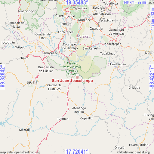
| Upper-left | 19.05483°, | -99.82842° |
| Center: | 18.38891°, | -99.12529° |
| Lower-right: | 17.72041°, | -98.42217° |
| Map W x H: | 148.4×148.4 km | = 92.2×92.2mi |
| max Lat: | 32.7° ⇑74% North |
| San Juan Teocalcingo: | 18.38891° |
| min Lat: | ⇓26% South 14.53588° |
| min Long | San Juan Teocal | max Long |
| -117.105° | -99.12529° | -86.73105° |
| W 48.4%⇐ | ⇒51.6% E |
Elevation
Elevation of San Juan Teocalcingo is 1060 m = 3478 ft, and this is 193.7 m = 635 ft below average elevation for this country.
| Max E: |
3497 m = 11473 ft | 58.8% |
| Avg. | 1253.7 m = 4113 ft | |
| San Juan Teocalcingo | 1060 m = 3478 ft | |
Min E: |
-1 m = -3 ft | 41.2% |
See also: Mexico elevation on elevation.city.
Geographical zone
San Juan Teocalcingo is located in North Torrid zone (between Equator and Tropic of Cancer). Distance of this Northern Tropic circle is 561.3 km =348.8 mi to North.| Distance of | km | miles | from San Juan Teocalcingo |
|---|---|---|---|
| North Pole | 7962.4 | 4947.6 | to North |
| Arctic Circle | 5356.5 | 3328.4 | to North |
| Tropic Cancer | 561.3 | 348.8 | to North |
| Equator | 2044.7 | 1270.5 | to South |


Nearby cities:
15 places around San Juan Teocalcingo: (largest is in red/bold)
• Chaucingo
9.9 km =6.2 mi,  173°
173°
• Escuchapa
15.5 km =9.6 mi,  234°
234°
• Higuerón
21.8 km =13.5 mi,  344°
344°
• Huachinantla
20.4 km =12.7 mi,  125°
125°
• Huautla
12 km =7.5 mi,  61°
61°
• La Mezquitera
19.4 km =12.1 mi,  7°
7°
• Lorenzo Vázquez (Santa Cruz)
21.3 km =13.2 mi,  15°
15°
• Palo Grande
22.9 km =14.2 mi,  354°
354°
• Paso Morelos
20.7 km =12.9 mi,  205°
205°
• Quetzalapa
8.9 km =5.5 mi, 227°
• Quilamula
17.6 km =10.9 mi,  39°
39°
• San Miguel de las Palmas
17.2 km =10.7 mi, 207°
• Teutla
21.7 km =13.5 mi,  120°
120°
• Tilzapotla
19.3 km =12 mi,  305°
305°
• Valle de Vázquez
16.6 km =10.3 mi, 20°
Sources, notices
• [Note1] Compared only with cities in Mexico existing in our database
• [Src1] Map data: © OpenStreetMap contributors (CC-BY-SA)
• [Src2] Other city data from geonames.org with taken over terms of usage.
• [Src3] Geographical zone / Annual Mean Temperature by Robert A. Rohde @ Wikipedia
