Tunkas geodata
Tunkas (Yucatán) is a populated place; located in Mexico in America/Merida (GMT-6) time zone. With population of 2,828 people, there are 3137 cities with bigger population in this country. Compared to other cities in Mexico, 74.9% of cities are located further ↓South; 99% of cities are located further ←West and 92.5% of cities have higher elevation than Tunkas. Note1


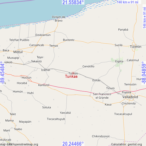
Tunkas GPS coordinates[2]
20° 54' 10.584" North, 88° 45' 6.156" West
| Map corner | latitude | longitude |
|---|---|---|
| Upper-left | 21.55834°, | -89.45484° |
| Center: | 20.90294°, | -88.75171° |
| Lower-right: | 20.24466°, | -88.04859° |
| Map W x H: | 146.1×146.1 km | = 90.8×90.8mi |
| max Lat: | 32.7° ⇑25.1% North |
| Tunkas: | 20.90294° |
| min Lat: | ⇓74.9% South 14.53588° |
| min Long | Tunkas | max Long |
| -117.105° | -88.75171° | -86.73105° |
| W 99%⇐ | ⇒1% E |
Elevation
Elevation of Tunkas is 18 m = 59 ft, and this is 1235.7 m = 4054 ft below average elevation for this country.
| Max E: |
3497 m = 11473 ft | 92.5% |
| Avg. | 1253.7 m = 4113 ft | |
| Tunkas | 18 m = 59 ft | |
Min E: |
-1 m = -3 ft | 7.5% |
See also: Mexico elevation on elevation.city.
Geographical zone
Tunkas is located in North Torrid zone (between Equator and Tropic of Cancer). Distance of this Northern Tropic circle is 281.7 km =175 mi to North.| Distance of | km | miles | from Tunkas |
|---|---|---|---|
| North Pole | 7682.9 | 4773.9 | to North |
| Arctic Circle | 5077 | 3154.7 | to North |
| Tropic Cancer | 281.7 | 175 | to North |
| Equator | 2324.2 | 1444.2 | to South |


Nearby cities:
15 places around Tunkas: (largest is in red/bold)
• Cenotillo
16.8 km =10.4 mi,  65°
65°
• Cuauhtémoc
25.8 km =16 mi,  266°
266°
• Dzitás
24.1 km =15 mi,  106°
106°
• Dzoncauich
29 km =18 mi,  330°
330°
• Holca
24.6 km =15.3 mi,  228°
228°
• Izamal
27.9 km =17.3 mi,  277°
277°
• Libre Unión
22.7 km =14.1 mi,  195°
195°
• Piste
28.2 km =17.5 mi,  143°
143°
• Quintana Roo
13 km =8.1 mi, 106°
• Sitilpech
21.7 km =13.5 mi, 281°
• Sudzal
24.9 km =15.5 mi,  262°
262°
• Tekal de Venegas
23.8 km =14.8 mi,  301°
301°
• Xanabá
28.2 km =17.5 mi,  254°
254°
• Xocempich
23.7 km =14.7 mi,  127°
127°
• Yokdzonot
21.6 km =13.4 mi,  174°
174°
Sources, notices
• [Note1] Compared only with cities in Mexico existing in our database
• [Src1] Map data: © OpenStreetMap contributors (CC-BY-SA)
• [Src2] Other city data from geonames.org with taken over terms of usage.
• [Src3] Geographical zone / Annual Mean Temperature by Robert A. Rohde @ Wikipedia
