Piedra Pinta geodata
Piedra Pinta (Veracruz) is a populated place; located in Mexico in America/Mexico_City (GMT-6) time zone. With population of 1,755 people, there are 4949 cities with bigger population in this country. Compared to other cities in Mexico, 56.8% of cities are located further ↓South; 72.5% of cities are located further ←West and 71.8% of cities have higher elevation than Piedra Pinta. Note1


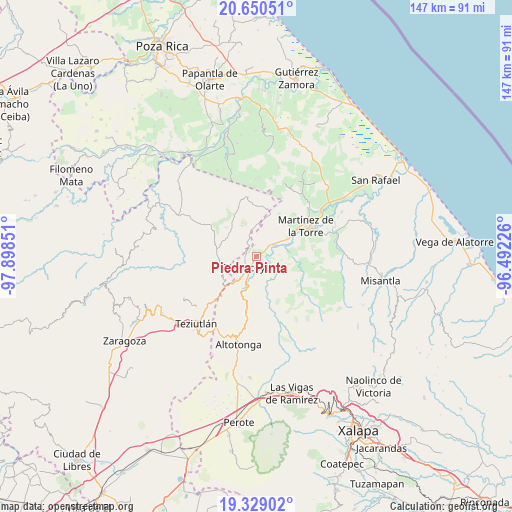
Piedra Pinta GPS coordinates[2]
19° 59' 28.14" North, 97° 11' 43.368" West
| Map corner | latitude | longitude |
|---|---|---|
| Upper-left | 20.65051°, | -97.89851° |
| Center: | 19.99115°, | -97.19538° |
| Lower-right: | 19.32902°, | -96.49226° |
| Map W x H: | 146.9×146.9 km | = 91.3×91.3mi |
| max Lat: | 32.7° ⇑43.2% North |
| Piedra Pinta: | 19.99115° |
| min Lat: | ⇓56.8% South 14.53588° |
| min Long | Piedra Pinta | max Long |
| -117.105° | -97.19538° | -86.73105° |
| W 72.5%⇐ | ⇒27.5% E |
Elevation
Elevation of Piedra Pinta is 335 m = 1099 ft, and this is 918.7 m = 3014 ft below average elevation for this country.
| Max E: |
3497 m = 11473 ft | 71.8% |
| Avg. | 1253.7 m = 4113 ft | |
| Piedra Pinta | 335 m = 1099 ft | |
Min E: |
-1 m = -3 ft | 28.2% |
See also: Mexico elevation on elevation.city.
Geographical zone
Piedra Pinta is located in North Torrid zone (between Equator and Tropic of Cancer). Distance of this Northern Tropic circle is 383.1 km =238 mi to North.| Distance of | km | miles | from Piedra Pinta |
|---|---|---|---|
| North Pole | 7784.3 | 4836.9 | to North |
| Arctic Circle | 5178.4 | 3217.7 | to North |
| Tropic Cancer | 383.1 | 238 | to North |
| Equator | 2222.8 | 1381.2 | to South |


Nearby cities:
15 places around Piedra Pinta: (largest is in red/bold)
• Atehuetzin
6.6 km =4.1 mi,  291°
291°
• Congregación Hidalgo
6.7 km =4.2 mi,  240°
240°
• Cuauzapotitán
10.1 km =6.3 mi,  173°
173°
• El Arco
7.9 km =4.9 mi,  215°
215°
• El Campamento
5.3 km =3.3 mi,  148°
148°
• El Jobo
4.1 km =2.5 mi,  51°
51°
• Eytepéquez
7 km =4.3 mi, 215°
• Jiliapan
9.5 km =5.9 mi,  3°
3°
• La Palmilla
6.1 km =3.8 mi,  58°
58°
• Limontitán Grande
8.7 km =5.4 mi,  268°
268°
• Napoala
10 km =6.2 mi,  196°
196°
• San Isidro
4.3 km =2.7 mi,  227°
227°
• Santa Cruz
6.5 km =4 mi, 202°
• Santiago
9.3 km =5.8 mi, 152°
• Tlapacoyan
3.6 km =2.2 mi,  207°
207°
Sources, notices
• [Note1] Compared only with cities in Mexico existing in our database
• [Src1] Map data: © OpenStreetMap contributors (CC-BY-SA)
• [Src2] Other city data from geonames.org with taken over terms of usage.
• [Src3] Geographical zone / Annual Mean Temperature by Robert A. Rohde @ Wikipedia
