Tlapacoyan geodata
Tlapacoyan (Veracruz) is a seat of a second-order administrative division; located in Mexico in America/Mexico_City (GMT-6) time zone. With population of 35,338 people, there are 289 cities with bigger population in this country. Compared to other cities in Mexico, 56.2% of cities are located further ↓South; 72.3% of cities are located further ←West and 69.4% of cities have higher elevation than Tlapacoyan. Note1


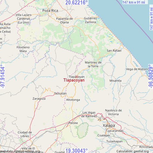
Tlapacoyan GPS coordinates[2]
19° 57' 45.648" North, 97° 12' 41.076" West
| Map corner | latitude | longitude |
|---|---|---|
| Upper-left | 20.62216°, | -97.91454° |
| Center: | 19.96268°, | -97.21141° |
| Lower-right: | 19.30043°, | -96.50829° |
| Map W x H: | 147×147 km | = 91.3×91.3mi |
| max Lat: | 32.7° ⇑43.8% North |
| Tlapacoyan: | 19.96268° |
| min Lat: | ⇓56.2% South 14.53588° |
| min Long | Tlapacoyan | max Long |
| -117.105° | -97.21141° | -86.73105° |
| W 72.3%⇐ | ⇒27.7% E |
Elevation
Elevation of Tlapacoyan is 446 m = 1463 ft, and this is 807.7 m = 2650 ft below average elevation for this country.
| Max E: |
3497 m = 11473 ft | 69.4% |
| Avg. | 1253.7 m = 4113 ft | |
| Tlapacoyan | 446 m = 1463 ft | |
Min E: |
-1 m = -3 ft | 30.6% |
See also: Mexico elevation on elevation.city.
Geographical zone
Tlapacoyan is located in North Torrid zone (between Equator and Tropic of Cancer). Distance of this Northern Tropic circle is 386.3 km =240 mi to North.| Distance of | km | miles | from Tlapacoyan |
|---|---|---|---|
| North Pole | 7787.4 | 4838.9 | to North |
| Arctic Circle | 5181.5 | 3219.6 | to North |
| Tropic Cancer | 386.3 | 240 | to North |
| Equator | 2219.6 | 1379.2 | to South |


Nearby cities:
15 places around Tlapacoyan: (largest is in red/bold)
• Atehuetzin
7.2 km =4.5 mi,  321°
321°
• Congregación Hidalgo
4.2 km =2.6 mi,  268°
268°
• Cuauzapotitán
7.5 km =4.7 mi,  157°
157°
• El Arco
4.4 km =2.7 mi,  222°
222°
• El Campamento
4.7 km =2.9 mi,  107°
107°
• El Jobo
7.5 km =4.7 mi,  40°
40°
• Eytepéquez
3.5 km =2.2 mi, 223°
• Hueytamalco
8.4 km =5.2 mi,  252°
252°
• Limontitán Grande
7.7 km =4.8 mi,  293°
293°
• Napoala
6.5 km =4 mi,  189°
189°
• Piedra Pinta
3.6 km =2.2 mi,  27°
27°
• San Isidro
1.5 km =0.9 mi,  277°
277°
• Santa Cruz
2.9 km =1.8 mi,  195°
195°
• Santiago
7.9 km =4.9 mi,  130°
130°
• Vicente Guerrero
7.7 km =4.8 mi,  229°
229°
Sources, notices
• [Note1] Compared only with cities in Mexico existing in our database
• [Src1] Map data: © OpenStreetMap contributors (CC-BY-SA)
• [Src2] Other city data from geonames.org with taken over terms of usage.
• [Src3] Geographical zone / Annual Mean Temperature by Robert A. Rohde @ Wikipedia
