Atehuetzin geodata
Atehuetzin (Puebla) is a populated place; located in Mexico in America/Mexico_City (GMT-6) time zone. With population of 716 people, there are 12166 cities with bigger population in this country. Compared to other cities in Mexico, 57.3% of cities are located further ↓South; 71.9% of cities are located further ←West and 68.8% of cities have higher elevation than Atehuetzin. Note1


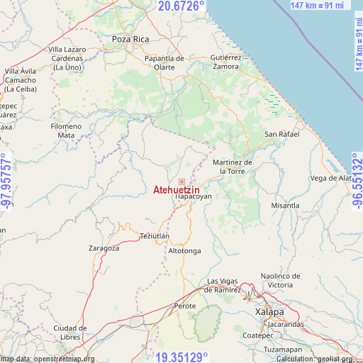
Atehuetzin GPS coordinates[2]
20° 0' 47.988" North, 97° 15' 15.984" West
| Map corner | latitude | longitude |
|---|---|---|
| Upper-left | 20.6726°, | -97.95757° |
| Center: | 20.01333°, | -97.25444° |
| Lower-right: | 19.35129°, | -96.55132° |
| Map W x H: | 146.9×146.9 km | = 91.3×91.3mi |
| max Lat: | 32.7° ⇑42.7% North |
| Atehuetzin: | 20.01333° |
| min Lat: | ⇓57.3% South 14.53588° |
| min Long | Atehuetzin | max Long |
| -117.105° | -97.25444° | -86.73105° |
| W 71.9%⇐ | ⇒28.1% E |
Elevation
Elevation of Atehuetzin is 481 m = 1578 ft, and this is 772.7 m = 2535 ft below average elevation for this country.
| Max E: |
3497 m = 11473 ft | 68.8% |
| Avg. | 1253.7 m = 4113 ft | |
| Atehuetzin | 481 m = 1578 ft | |
Min E: |
-1 m = -3 ft | 31.2% |
See also: Mexico elevation on elevation.city.
Geographical zone
Atehuetzin is located in North Torrid zone (between Equator and Tropic of Cancer). Distance of this Northern Tropic circle is 380.6 km =236.5 mi to North.| Distance of | km | miles | from Atehuetzin |
|---|---|---|---|
| North Pole | 7781.8 | 4835.4 | to North |
| Arctic Circle | 5175.9 | 3216.2 | to North |
| Tropic Cancer | 380.6 | 236.5 | to North |
| Equator | 2225.3 | 1382.7 | to South |


Nearby cities:
15 places around Atehuetzin: (largest is in red/bold)
• Amatetel
8.2 km =5.1 mi,  220°
220°
• Congregación Hidalgo
5.8 km =3.6 mi,  177°
177°
• Conta
10.7 km =6.6 mi,  207°
207°
• El Arco
9 km =5.6 mi,  170°
170°
• El Jobo
9.4 km =5.8 mi,  89°
89°
• Eytepéquez
8.4 km =5.2 mi, 165°
• Hueytamalco
8.9 km =5.5 mi,  203°
203°
• Jiliapan
9.7 km =6 mi,  43°
43°
• La Palmilla
11.4 km =7.1 mi, 86°
• Limontitán Grande
3.7 km =2.3 mi, 224°
• Piedra Pinta
6.6 km =4.1 mi,  111°
111°
• San Isidro
6.2 km =3.9 mi,  151°
151°
• Santa Cruz
9.2 km =5.7 mi,  156°
156°
• Tlapacoyan
7.2 km =4.5 mi,  141°
141°
• Vicente Guerrero
10.7 km =6.6 mi,  187°
187°
Sources, notices
• [Note1] Compared only with cities in Mexico existing in our database
• [Src1] Map data: © OpenStreetMap contributors (CC-BY-SA)
• [Src2] Other city data from geonames.org with taken over terms of usage.
• [Src3] Geographical zone / Annual Mean Temperature by Robert A. Rohde @ Wikipedia
