Pich geodata
Pich (Campeche) is a populated place; located in Mexico in America/Merida (GMT-6) time zone. With population of 1,756 people, there are 4942 cities with bigger population in this country. Compared to other cities in Mexico, 54.4% of cities are located further ↑North; 97.5% of cities are located further ←West and 78.7% of cities have higher elevation than Pich. Note1


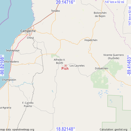
Pich GPS coordinates[2]
19° 29' 8.448" North, 90° 7' 4.62" West
| Map corner | latitude | longitude |
|---|---|---|
| Upper-left | 20.14716°, | -90.82108° |
| Center: | 19.48568°, | -90.11795° |
| Lower-right: | 18.82148°, | -89.41483° |
| Map W x H: | 147.4×147.4 km | = 91.6×91.6mi |
| max Lat: | 32.7° ⇑54.4% North |
| Pich: | 19.48568° |
| min Lat: | ⇓45.6% South 14.53588° |
| min Long | Pich | max Long |
| -117.105° | -90.11795° | -86.73105° |
| W 97.5%⇐ | ⇒2.5% E |
Elevation
Elevation of Pich is 117 m = 384 ft, and this is 1136.7 m = 3729 ft below average elevation for this country.
| Max E: |
3497 m = 11473 ft | 78.7% |
| Avg. | 1253.7 m = 4113 ft | |
| Pich | 117 m = 384 ft | |
Min E: |
-1 m = -3 ft | 21.3% |
See also: Mexico elevation on elevation.city.
Geographical zone
Pich is located in North Torrid zone (between Equator and Tropic of Cancer). Distance of this Northern Tropic circle is 439.3 km =273 mi to North.| Distance of | km | miles | from Pich |
|---|---|---|---|
| North Pole | 7840.5 | 4871.9 | to North |
| Arctic Circle | 5234.6 | 3252.6 | to North |
| Tropic Cancer | 439.3 | 273 | to North |
| Equator | 2166.6 | 1346.3 | to South |


Nearby cities:
15 places around Pich: (largest is in red/bold)
• Alfredo V. Bonfil
8.4 km =5.2 mi,  306°
306°
• Crucero San Luis
27.3 km =17 mi,  29°
29°
• Hool
34.5 km =21.4 mi,  275°
275°
• Ich-Ek
31.7 km =19.7 mi, 29°
• Kikab
23.9 km =14.9 mi,  203°
203°
• Konchén
30.4 km =18.9 mi,  66°
66°
• Los Laureles
12.9 km =8 mi,  88°
88°
• Melchor Ocampo
16.9 km =10.5 mi,  222°
222°
• Nohakal
29.5 km =18.3 mi, 309°
• Pocyaxum
36.4 km =22.6 mi,  317°
317°
• Quetzal Edzná
3.3 km =2.1 mi,  155°
155°
• Santa Rita
31.7 km =19.7 mi,  54°
54°
• Suc-Tuc
26.6 km =16.5 mi,  18°
18°
• Tikinmul
33.1 km =20.6 mi,  340°
340°
• Xcupil
33.7 km =20.9 mi, 53°
Sources, notices
• [Note1] Compared only with cities in Mexico existing in our database
• [Src1] Map data: © OpenStreetMap contributors (CC-BY-SA)
• [Src2] Other city data from geonames.org with taken over terms of usage.
• [Src3] Geographical zone / Annual Mean Temperature by Robert A. Rohde @ Wikipedia
