Melchor Ocampo geodata
Melchor Ocampo (Campeche) is a populated place; located in Mexico in America/Merida (GMT-6) time zone. With population of 983 people, there are 8847 cities with bigger population in this country. Compared to other cities in Mexico, 56.9% of cities are located further ↑North; 97.3% of cities are located further ←West and 87.5% of cities have higher elevation than Melchor Ocampo. Note1


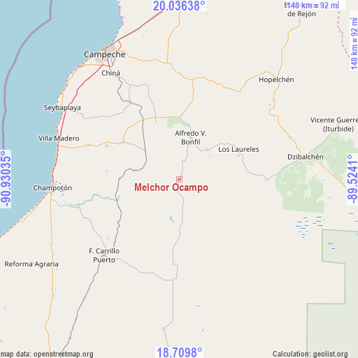
Melchor Ocampo GPS coordinates[2]
19° 22' 27.984" North, 90° 13' 37.992" West
| Map corner | latitude | longitude |
|---|---|---|
| Upper-left | 20.03638°, | -90.93035° |
| Center: | 19.37444°, | -90.22722° |
| Lower-right: | 18.7098°, | -89.5241° |
| Map W x H: | 147.5×147.5 km | = 91.7×91.7mi |
| max Lat: | 32.7° ⇑56.9% North |
| Melchor Ocampo: | 19.37444° |
| min Lat: | ⇓43.1% South 14.53588° |
| min Long | Melchor Ocampo | max Long |
| -117.105° | -90.22722° | -86.73105° |
| W 97.3%⇐ | ⇒2.7% E |
Elevation
Elevation of Melchor Ocampo is 32 m = 105 ft, and this is 1221.7 m = 4008 ft below average elevation for this country.
| Max E: |
3497 m = 11473 ft | 87.5% |
| Avg. | 1253.7 m = 4113 ft | |
| Melchor Ocampo | 32 m = 105 ft | |
Min E: |
-1 m = -3 ft | 12.5% |
See also: Mexico elevation on elevation.city.
Geographical zone
Melchor Ocampo is located in North Torrid zone (between Equator and Tropic of Cancer). Distance of this Northern Tropic circle is 451.7 km =280.7 mi to North.| Distance of | km | miles | from Melchor Ocampo |
|---|---|---|---|
| North Pole | 7852.8 | 4879.5 | to North |
| Arctic Circle | 5246.9 | 3260.3 | to North |
| Tropic Cancer | 451.7 | 280.7 | to North |
| Equator | 2154.2 | 1338.6 | to South |


Nearby cities:
15 places around Melchor Ocampo: (largest is in red/bold)
• Alfredo V. Bonfil
18 km =11.2 mi,  15°
15°
• Hool
27.7 km =17.2 mi,  303°
303°
• Kikab
9.7 km =6 mi,  168°
168°
• Los Laureles
27.5 km =17.1 mi,  62°
62°
• Maya Tecún I
38.3 km =23.8 mi,  229°
229°
• Maya Tecún II
37.4 km =23.2 mi, 231°
• Nohakal
33.1 km =20.6 mi,  339°
339°
• Pich
16.9 km =10.5 mi,  42°
42°
• Pocyaxum
41.5 km =25.8 mi, 341°
• Pustunich
36.9 km =22.9 mi, 225°
• Quetzal Edzná
15.9 km =9.9 mi,  53°
53°
• Santo Domingo Kesté
32.9 km =20.4 mi, 295°
• Sihochac
40 km =24.9 mi,  290°
290°
• Suc-Tuc
42.5 km =26.4 mi,  27°
27°
• Yohaltún
41.2 km =25.6 mi,  192°
192°
Sources, notices
• [Note1] Compared only with cities in Mexico existing in our database
• [Src1] Map data: © OpenStreetMap contributors (CC-BY-SA)
• [Src2] Other city data from geonames.org with taken over terms of usage.
• [Src3] Geographical zone / Annual Mean Temperature by Robert A. Rohde @ Wikipedia
