Kikab geodata
Kikab (Campeche) is a populated place; located in Mexico in America/Merida (GMT-6) time zone. With population of 509 people, there are 16517 cities with bigger population in this country. Compared to other cities in Mexico, 59.1% of cities are located further ↑North; 97.4% of cities are located further ←West and 87.7% of cities have higher elevation than Kikab. Note1


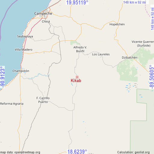
Kikab GPS coordinates[2]
19° 17' 20.004" North, 90° 12' 33.012" West
| Map corner | latitude | longitude |
|---|---|---|
| Upper-left | 19.95119°, | -90.9123° |
| Center: | 19.28889°, | -90.20917° |
| Lower-right: | 18.6239°, | -89.50605° |
| Map W x H: | 147.6×147.6 km | = 91.7×91.7mi |
| max Lat: | 32.7° ⇑59.1% North |
| Kikab: | 19.28889° |
| min Lat: | ⇓40.9% South 14.53588° |
| min Long | Kikab | max Long |
| -117.105° | -90.20917° | -86.73105° |
| W 97.4%⇐ | ⇒2.6% E |
Elevation
Elevation of Kikab is 31 m = 102 ft, and this is 1222.7 m = 4011 ft below average elevation for this country.
| Max E: |
3497 m = 11473 ft | 87.7% |
| Avg. | 1253.7 m = 4113 ft | |
| Kikab | 31 m = 102 ft | |
Min E: |
-1 m = -3 ft | 12.3% |
See also: Mexico elevation on elevation.city.
Geographical zone
Kikab is located in North Torrid zone (between Equator and Tropic of Cancer). Distance of this Northern Tropic circle is 461.2 km =286.6 mi to North.| Distance of | km | miles | from Kikab |
|---|---|---|---|
| North Pole | 7862.3 | 4885.4 | to North |
| Arctic Circle | 5256.5 | 3266.2 | to North |
| Tropic Cancer | 461.2 | 286.6 | to North |
| Equator | 2144.7 | 1332.7 | to South |


Nearby cities:
15 places around Kikab: (largest is in red/bold)
• Alfredo V. Bonfil
27 km =16.8 mi,  6°
6°
• Carrillo Puerto
39.4 km =24.5 mi,  236°
236°
• Hool
35.2 km =21.9 mi,  315°
315°
• Los Laureles
31.6 km =19.6 mi,  45°
45°
• Maya Tecún I
34.7 km =21.6 mi, 244°
• Maya Tecún II
34.1 km =21.2 mi,  246°
246°
• Melchor Ocampo
9.7 km =6 mi,  348°
348°
• Nohakal
42.7 km =26.5 mi,  341°
341°
• Pich
23.9 km =14.9 mi,  23°
23°
• Pustunich
32.7 km =20.3 mi, 240°
• Quetzal Edzná
21.8 km =13.5 mi,  30°
30°
• Santo Domingo Kesté
39.4 km =24.5 mi,  306°
306°
• Sihochac
45.9 km =28.5 mi,  300°
300°
• Ulumal
43.5 km =27 mi,  267°
267°
• Yohaltún
32.6 km =20.3 mi,  199°
199°
Sources, notices
• [Note1] Compared only with cities in Mexico existing in our database
• [Src1] Map data: © OpenStreetMap contributors (CC-BY-SA)
• [Src2] Other city data from geonames.org with taken over terms of usage.
• [Src3] Geographical zone / Annual Mean Temperature by Robert A. Rohde @ Wikipedia
