Palomas geodata
Palomas (San Luis Potosí) is a populated place; located in Mexico in America/Mexico_City (GMT-6) time zone. With population of 2,676 people, there are 3302 cities with bigger population in this country. Compared to other cities in Mexico, 86.6% of cities are located further ↓South; 62.1% of cities are located further →East and 59.6% of cities have higher elevation than Palomas. Note1


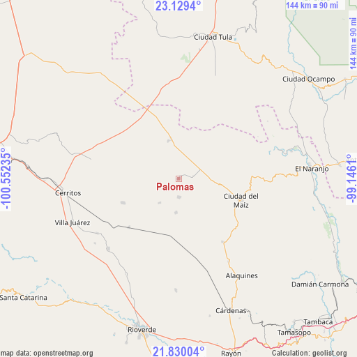
Palomas GPS coordinates[2]
22° 28' 52.464" North, 99° 50' 57.192" West
| Map corner | latitude | longitude |
|---|---|---|
| Upper-left | 23.1294°, | -100.55235° |
| Center: | 22.48124°, | -99.84922° |
| Lower-right: | 21.83004°, | -99.1461° |
| Map W x H: | 144.5×144.5 km | = 89.8×89.8mi |
| max Lat: | 32.7° ⇑13.4% North |
| Palomas: | 22.48124° |
| min Lat: | ⇓86.6% South 14.53588° |
| min Long | Palomas | max Long |
| -117.105° | -99.84922° | -86.73105° |
| W 37.9%⇐ | ⇒62.1% E |
Elevation
Elevation of Palomas is 1023 m = 3356 ft, and this is 230.7 m = 757 ft below average elevation for this country.
| Max E: |
3497 m = 11473 ft | 59.6% |
| Avg. | 1253.7 m = 4113 ft | |
| Palomas | 1023 m = 3356 ft | |
Min E: |
-1 m = -3 ft | 40.4% |
See also: Mexico elevation on elevation.city.
Geographical zone
Palomas is located in North Torrid zone (between Equator and Tropic of Cancer). Distance of this Northern Tropic circle is 106.2 km =66 mi to North.| Distance of | km | miles | from Palomas |
|---|---|---|---|
| North Pole | 7507.4 | 4664.9 | to North |
| Arctic Circle | 4901.5 | 3045.6 | to North |
| Tropic Cancer | 106.2 | 66 | to North |
| Equator | 2499.7 | 1553.2 | to South |


Nearby cities:
15 places around Palomas: (largest is in red/bold)
• Buenavista
32.8 km =20.4 mi,  293°
293°
• Ciudad del Maíz
26.6 km =16.5 mi,  109°
109°
• Colonia la Libertad
7.4 km =4.6 mi,  178°
178°
• Colonia Álvaro Obregón
31.2 km =19.4 mi,  144°
144°
• El Custodio
22.6 km =14 mi,  326°
326°
• Emiliano Zapata
33.8 km =21 mi,  336°
336°
• Granjenal
24.6 km =15.3 mi,  246°
246°
• La Hincada
33 km =20.5 mi,  306°
306°
• Lagunillas
33.6 km =20.9 mi,  120°
120°
• Magdaleno Cedillo
35.4 km =22 mi,  345°
345°
• Ojo de Agua
25.4 km =15.8 mi,  260°
260°
• San Bartolo
28.1 km =17.5 mi,  225°
225°
• San Rafael Matriz
15.9 km =9.9 mi, 345°
• Tanque de los Ángeles
12.4 km =7.7 mi,  218°
218°
• Zamachihue
20.1 km =12.5 mi,  80°
80°
Sources, notices
• [Note1] Compared only with cities in Mexico existing in our database
• [Src1] Map data: © OpenStreetMap contributors (CC-BY-SA)
• [Src2] Other city data from geonames.org with taken over terms of usage.
• [Src3] Geographical zone / Annual Mean Temperature by Robert A. Rohde @ Wikipedia
