Granjenal geodata
Granjenal (San Luis Potosí) is a populated place; located in Mexico in America/Mexico_City (GMT-6) time zone. With population of 1,496 people, there are 5771 cities with bigger population in this country. Compared to other cities in Mexico, 86.2% of cities are located further ↓South; 64.8% of cities are located further →East and 58.4% of cities have higher elevation than Granjenal. Note1


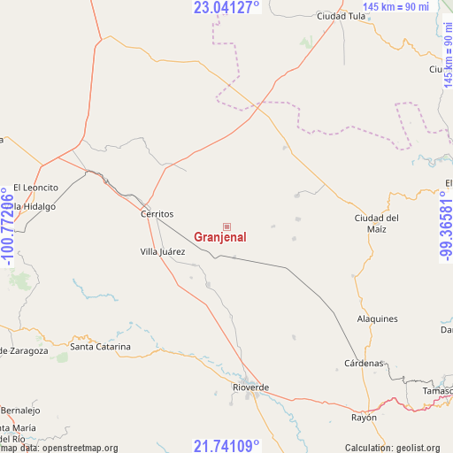
Granjenal GPS coordinates[2]
22° 23' 33.72" North, 100° 4' 8.148" West
| Map corner | latitude | longitude |
|---|---|---|
| Upper-left | 23.04127°, | -100.77206° |
| Center: | 22.3927°, | -100.06893° |
| Lower-right: | 21.74109°, | -99.36581° |
| Map W x H: | 144.6×144.6 km | = 89.9×89.9mi |
| max Lat: | 32.7° ⇑13.8% North |
| Granjenal: | 22.3927° |
| min Lat: | ⇓86.2% South 14.53588° |
| min Long | Granjenal | max Long |
| -117.105° | -100.06893° | -86.73105° |
| W 35.2%⇐ | ⇒64.8% E |
Elevation
Elevation of Granjenal is 1089 m = 3573 ft, and this is 164.7 m = 540 ft below average elevation for this country.
| Max E: |
3497 m = 11473 ft | 58.4% |
| Avg. | 1253.7 m = 4113 ft | |
| Granjenal | 1089 m = 3573 ft | |
Min E: |
-1 m = -3 ft | 41.6% |
See also: Mexico elevation on elevation.city.
Geographical zone
Granjenal is located in North Torrid zone (between Equator and Tropic of Cancer). Distance of this Northern Tropic circle is 116.1 km =72.1 mi to North.| Distance of | km | miles | from Granjenal |
|---|---|---|---|
| North Pole | 7517.2 | 4671 | to North |
| Arctic Circle | 4911.3 | 3051.7 | to North |
| Tropic Cancer | 116.1 | 72.1 | to North |
| Equator | 2489.8 | 1547.1 | to South |


Nearby cities:
15 places around Granjenal: (largest is in red/bold)
• Buenavista
24.1 km =15 mi,  341°
341°
• Cerritos
22.5 km =14 mi,  280°
280°
• Colonia la Libertad
22.9 km =14.2 mi,  83°
83°
• Derramaderos
25.1 km =15.6 mi,  302°
302°
• El Quelital
21.6 km =13.4 mi,  323°
323°
• Ojo de Agua
6.2 km =3.9 mi, 336°
• Palo Seco (El Gato)
13.4 km =8.3 mi,  251°
251°
• Palomas
24.6 km =15.3 mi,  66°
66°
• Pastora
28.6 km =17.8 mi,  177°
177°
• Progreso
19.3 km =12 mi,  198°
198°
• Puerta del Río
26.1 km =16.2 mi,  229°
229°
• San Bartolo
10.2 km =6.3 mi,  165°
165°
• Santo Domingo
16 km =9.9 mi,  220°
220°
• Tanque de los Ángeles
15 km =9.3 mi,  89°
89°
• Villa Juárez
21.7 km =13.5 mi, 250°
Sources, notices
• [Note1] Compared only with cities in Mexico existing in our database
• [Src1] Map data: © OpenStreetMap contributors (CC-BY-SA)
• [Src2] Other city data from geonames.org with taken over terms of usage.
• [Src3] Geographical zone / Annual Mean Temperature by Robert A. Rohde @ Wikipedia
