San Vicente Palapa geodata
San Vicente Palapa (Guerrero) is a populated place; located in Mexico in America/Mexico_City (GMT-6) time zone. With population of 1,130 people, there are 7675 cities with bigger population in this country. Compared to other cities in Mexico, 74.6% of cities are located further ↑North; 55.7% of cities are located further →East and 62.5% of cities have higher elevation than San Vicente Palapa. Note1


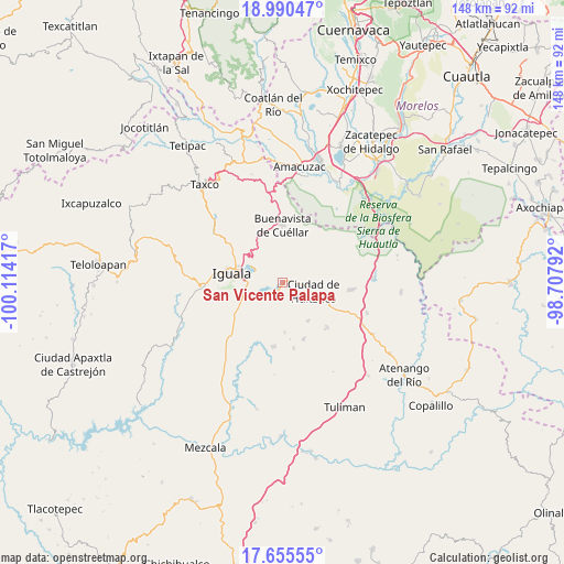
San Vicente Palapa GPS coordinates[2]
18° 19' 27.48" North, 99° 24' 39.744" West
| Map corner | latitude | longitude |
|---|---|---|
| Upper-left | 18.99047°, | -100.11417° |
| Center: | 18.3243°, | -99.41104° |
| Lower-right: | 17.65555°, | -98.70792° |
| Map W x H: | 148.4×148.4 km | = 92.2×92.2mi |
| max Lat: | 32.7° ⇑74.6% North |
| San Vicente Palapa: | 18.3243° |
| min Lat: | ⇓25.4% South 14.53588° |
| min Long | San Vicente Pal | max Long |
| -117.105° | -99.41104° | -86.73105° |
| W 44.3%⇐ | ⇒55.7% E |
Elevation
Elevation of San Vicente Palapa is 856 m = 2808 ft, and this is 397.7 m = 1305 ft below average elevation for this country.
| Max E: |
3497 m = 11473 ft | 62.5% |
| Avg. | 1253.7 m = 4113 ft | |
| San Vicente Palapa | 856 m = 2808 ft | |
Min E: |
-1 m = -3 ft | 37.5% |
See also: Mexico elevation on elevation.city.
Geographical zone
San Vicente Palapa is located in North Torrid zone (between Equator and Tropic of Cancer). Distance of this Northern Tropic circle is 568.4 km =353.2 mi to North.| Distance of | km | miles | from San Vicente Palapa |
|---|---|---|---|
| North Pole | 7969.6 | 4952.1 | to North |
| Arctic Circle | 5363.7 | 3332.8 | to North |
| Tropic Cancer | 568.4 | 353.2 | to North |
| Equator | 2037.5 | 1266 | to South |


Nearby cities:
15 places around San Vicente Palapa: (largest is in red/bold)
• Acayahualco
13.2 km =8.2 mi,  213°
213°
• Atetetla
4.1 km =2.5 mi,  83°
83°
• Ciudad de Huitzuco
8.5 km =5.3 mi,  105°
105°
• Colonia 15 de Septiembre
13.4 km =8.3 mi,  296°
296°
• Colonia Rancho del Cura (El Cura)
11.1 km =6.9 mi,  252°
252°
• Cuexcontlán
2.9 km =1.8 mi,  221°
221°
• Pololcingo
5.2 km =3.2 mi,  157°
157°
• Rincón de la Cocina
10.7 km =6.6 mi, 213°
• Santa Cruz
13.1 km =8.1 mi,  177°
177°
• Tepecoacuilco de Trujano
6.9 km =4.3 mi,  233°
233°
• Tepochica
12.2 km =7.6 mi,  258°
258°
• Tierra Colorada
9.3 km =5.8 mi, 229°
• Tlapala
12.1 km =7.5 mi,  145°
145°
• Tlaxmalac
4.1 km =2.5 mi,  356°
356°
• Tuxpan
7.8 km =4.8 mi,  291°
291°
Sources, notices
• [Note1] Compared only with cities in Mexico existing in our database
• [Src1] Map data: © OpenStreetMap contributors (CC-BY-SA)
• [Src2] Other city data from geonames.org with taken over terms of usage.
• [Src3] Geographical zone / Annual Mean Temperature by Robert A. Rohde @ Wikipedia
