Pololcingo geodata
Pololcingo (Guerrero) is a populated place; located in Mexico in America/Mexico_City (GMT-6) time zone. With population of 1,765 people, there are 4919 cities with bigger population in this country. Compared to other cities in Mexico, 75.1% of cities are located further ↑North; 55.5% of cities are located further →East and 61.5% of cities have higher elevation than Pololcingo. Note1


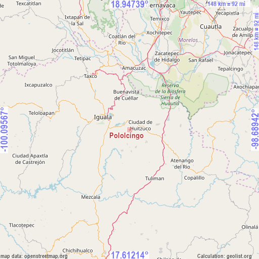
Pololcingo GPS coordinates[2]
18° 16' 51.78" North, 99° 23' 33.144" West
| Map corner | latitude | longitude |
|---|---|---|
| Upper-left | 18.94739°, | -100.09567° |
| Center: | 18.28105°, | -99.39254° |
| Lower-right: | 17.61214°, | -98.68942° |
| Map W x H: | 148.5×148.5 km | = 92.3×92.3mi |
| max Lat: | 32.7° ⇑75.1% North |
| Pololcingo: | 18.28105° |
| min Lat: | ⇓24.9% South 14.53588° |
| min Long | Pololcingo | max Long |
| -117.105° | -99.39254° | -86.73105° |
| W 44.5%⇐ | ⇒55.5% E |
Elevation
Elevation of Pololcingo is 906 m = 2972 ft, and this is 347.7 m = 1141 ft below average elevation for this country.
| Max E: |
3497 m = 11473 ft | 61.5% |
| Avg. | 1253.7 m = 4113 ft | |
| Pololcingo | 906 m = 2972 ft | |
Min E: |
-1 m = -3 ft | 38.5% |
See also: Mexico elevation on elevation.city.
Geographical zone
Pololcingo is located in North Torrid zone (between Equator and Tropic of Cancer). Distance of this Northern Tropic circle is 573.3 km =356.2 mi to North.| Distance of | km | miles | from Pololcingo |
|---|---|---|---|
| North Pole | 7974.4 | 4955.1 | to North |
| Arctic Circle | 5368.5 | 3335.8 | to North |
| Tropic Cancer | 573.3 | 356.2 | to North |
| Equator | 2032.7 | 1263.1 | to South |


Nearby cities:
15 places around Pololcingo: (largest is in red/bold)
• Acayahualco
11.2 km =7 mi,  236°
236°
• Atetetla
5.7 km =3.5 mi,  21°
21°
• Cacahuananche
10.6 km =6.6 mi,  159°
159°
• Ciudad de Huitzuco
6.7 km =4.2 mi,  68°
68°
• Cuexcontlán
4.7 km =2.9 mi,  304°
304°
• Lagunillas
12.3 km =7.6 mi,  125°
125°
• Rincón de la Cocina
8.9 km =5.5 mi, 242°
• San Vicente Palapa
5.2 km =3.2 mi,  337°
337°
• Santa Cruz
8.3 km =5.2 mi,  189°
189°
• Tepecoacuilco de Trujano
7.6 km =4.7 mi,  275°
275°
• Tierra Colorada
9.1 km =5.7 mi,  261°
261°
• Tlapala
7.1 km =4.4 mi,  137°
137°
• Tlaxmalac
9.2 km =5.7 mi,  346°
346°
• Tuxpan
11.9 km =7.4 mi,  309°
309°
• Xilocintla
12.4 km =7.7 mi,  175°
175°
Sources, notices
• [Note1] Compared only with cities in Mexico existing in our database
• [Src1] Map data: © OpenStreetMap contributors (CC-BY-SA)
• [Src2] Other city data from geonames.org with taken over terms of usage.
• [Src3] Geographical zone / Annual Mean Temperature by Robert A. Rohde @ Wikipedia
