Atetetla geodata
Atetetla (Guerrero) is a populated place; located in Mexico in America/Mexico_City (GMT-6) time zone. With population of 699 people, there are 12460 cities with bigger population in this country. Compared to other cities in Mexico, 74.6% of cities are located further ↑North; 55.3% of cities are located further →East and 61.3% of cities have higher elevation than Atetetla. Note1


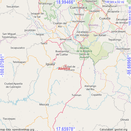
Atetetla GPS coordinates[2]
18° 19' 42.636" North, 99° 22' 22.008" West
| Map corner | latitude | longitude |
|---|---|---|
| Upper-left | 18.99466°, | -100.07591° |
| Center: | 18.32851°, | -99.37278° |
| Lower-right: | 17.65978°, | -98.66966° |
| Map W x H: | 148.4×148.4 km | = 92.2×92.2mi |
| max Lat: | 32.7° ⇑74.6% North |
| Atetetla: | 18.32851° |
| min Lat: | ⇓25.4% South 14.53588° |
| min Long | Atetetla | max Long |
| -117.105° | -99.37278° | -86.73105° |
| W 44.7%⇐ | ⇒55.3% E |
Elevation
Elevation of Atetetla is 918 m = 3012 ft, and this is 335.7 m = 1101 ft below average elevation for this country.
| Max E: |
3497 m = 11473 ft | 61.3% |
| Avg. | 1253.7 m = 4113 ft | |
| Atetetla | 918 m = 3012 ft | |
Min E: |
-1 m = -3 ft | 38.7% |
See also: Mexico elevation on elevation.city.
Geographical zone
Atetetla is located in North Torrid zone (between Equator and Tropic of Cancer). Distance of this Northern Tropic circle is 568 km =352.9 mi to North.| Distance of | km | miles | from Atetetla |
|---|---|---|---|
| North Pole | 7969.1 | 4951.8 | to North |
| Arctic Circle | 5363.2 | 3332.5 | to North |
| Tropic Cancer | 568 | 352.9 | to North |
| Equator | 2037.9 | 1266.3 | to South |


Nearby cities:
15 places around Atetetla: (largest is in red/bold)
• Buenavista de Cuéllar
15.1 km =9.4 mi,  345°
345°
• Ciudad de Huitzuco
5 km =3.1 mi,  124°
124°
• Colonia Rancho del Cura (El Cura)
15.1 km =9.4 mi,  255°
255°
• Cuexcontlán
6.5 km =4 mi,  246°
246°
• Escuchapa
13.8 km =8.6 mi,  99°
99°
• Lagunillas
14.7 km =9.1 mi,  147°
147°
• Pololcingo
5.7 km =3.5 mi,  201°
201°
• Rincón de la Cocina
13.7 km =8.5 mi,  226°
226°
• San Vicente Palapa
4.1 km =2.5 mi, 263°
• Santa Cruz
13.9 km =8.6 mi,  194°
194°
• Tepecoacuilco de Trujano
10.7 km =6.6 mi,  244°
244°
• Tierra Colorada
12.9 km =8 mi, 239°
• Tlapala
10.8 km =6.7 mi,  165°
165°
• Tlaxmalac
5.6 km =3.5 mi,  310°
310°
• Tuxpan
11.5 km =7.1 mi,  281°
281°
Sources, notices
• [Note1] Compared only with cities in Mexico existing in our database
• [Src1] Map data: © OpenStreetMap contributors (CC-BY-SA)
• [Src2] Other city data from geonames.org with taken over terms of usage.
• [Src3] Geographical zone / Annual Mean Temperature by Robert A. Rohde @ Wikipedia
