Acayahualco geodata
Acayahualco (Guerrero) is a populated place; located in Mexico in America/Mexico_City (GMT-6) time zone. With population of 925 people, there are 9432 cities with bigger population in this country. Compared to other cities in Mexico, 75.9% of cities are located further ↑North; 56.7% of cities are located further →East and 63.2% of cities have higher elevation than Acayahualco. Note1


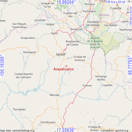
Acayahualco GPS coordinates[2]
18° 13' 31.728" North, 99° 28' 50.7" West
| Map corner | latitude | longitude |
|---|---|---|
| Upper-left | 18.89204°, | -100.18388° |
| Center: | 18.22548°, | -99.48075° |
| Lower-right: | 17.55636°, | -98.77763° |
| Map W x H: | 148.5×148.5 km | = 92.3×92.3mi |
| max Lat: | 32.7° ⇑75.9% North |
| Acayahualco: | 18.22548° |
| min Lat: | ⇓24.1% South 14.53588° |
| min Long | Acayahualco | max Long |
| -117.105° | -99.48075° | -86.73105° |
| W 43.3%⇐ | ⇒56.7% E |
Elevation
Elevation of Acayahualco is 806 m = 2644 ft, and this is 447.7 m = 1469 ft below average elevation for this country.
| Max E: |
3497 m = 11473 ft | 63.2% |
| Avg. | 1253.7 m = 4113 ft | |
| Acayahualco | 806 m = 2644 ft | |
Min E: |
-1 m = -3 ft | 36.8% |
See also: Mexico elevation on elevation.city.
Geographical zone
Acayahualco is located in North Torrid zone (between Equator and Tropic of Cancer). Distance of this Northern Tropic circle is 579.4 km =360 mi to North.| Distance of | km | miles | from Acayahualco |
|---|---|---|---|
| North Pole | 7980.6 | 4958.9 | to North |
| Arctic Circle | 5374.7 | 3339.7 | to North |
| Tropic Cancer | 579.4 | 360 | to North |
| Equator | 2026.5 | 1259.2 | to South |


Nearby cities:
15 places around Acayahualco: (largest is in red/bold)
• Ceja Blanca
11.5 km =7.1 mi,  311°
311°
• Colonia Rancho del Cura (El Cura)
8.2 km =5.1 mi,  337°
337°
• Cuexcontlán
10.4 km =6.5 mi,  31°
31°
• Mayanalán
7.7 km =4.8 mi,  138°
138°
• Pololcingo
11.2 km =7 mi,  56°
56°
• Rincón de la Cocina
2.5 km =1.6 mi,  35°
35°
• Sabana Grande
10.4 km =6.5 mi,  223°
223°
• Santa Cruz
8.2 km =5.1 mi,  104°
104°
• Santa Teresa
2.8 km =1.7 mi,  279°
279°
• Sasamulco
12.5 km =7.8 mi,  233°
233°
• Tepecoacuilco de Trujano
7.1 km =4.4 mi,  14°
14°
• Tepochica
9.7 km =6 mi,  331°
331°
• Tierra Colorada
4.9 km =3 mi,  3°
3°
• Xilocintla
12 km =7.5 mi,  120°
120°
• Zacacoyuca
5.7 km =3.5 mi,  299°
299°
Sources, notices
• [Note1] Compared only with cities in Mexico existing in our database
• [Src1] Map data: © OpenStreetMap contributors (CC-BY-SA)
• [Src2] Other city data from geonames.org with taken over terms of usage.
• [Src3] Geographical zone / Annual Mean Temperature by Robert A. Rohde @ Wikipedia
