Tuxpan geodata
Tuxpan (Guerrero) is a populated place; located in Mexico in America/Mexico_City (GMT-6) time zone. With population of 2,086 people, there are 4185 cities with bigger population in this country. Compared to other cities in Mexico, 74.3% of cities are located further ↑North; 56.7% of cities are located further →East and 63.8% of cities have higher elevation than Tuxpan. Note1


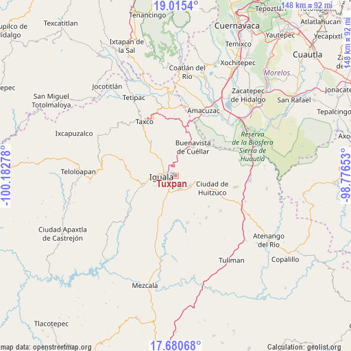
Tuxpan GPS coordinates[2]
18° 20' 57.588" North, 99° 28' 46.74" West
| Map corner | latitude | longitude |
|---|---|---|
| Upper-left | 19.0154°, | -100.18278° |
| Center: | 18.34933°, | -99.47965° |
| Lower-right: | 17.68068°, | -98.77653° |
| Map W x H: | 148.4×148.4 km | = 92.2×92.2mi |
| max Lat: | 32.7° ⇑74.3% North |
| Tuxpan: | 18.34933° |
| min Lat: | ⇓25.7% South 14.53588° |
| min Long | Tuxpan | max Long |
| -117.105° | -99.47965° | -86.73105° |
| W 43.3%⇐ | ⇒56.7% E |
Elevation
Elevation of Tuxpan is 762 m = 2500 ft, and this is 491.7 m = 1613 ft below average elevation for this country.
| Max E: |
3497 m = 11473 ft | 63.8% |
| Avg. | 1253.7 m = 4113 ft | |
| Tuxpan | 762 m = 2500 ft | |
Min E: |
-1 m = -3 ft | 36.2% |
See also: Mexico elevation on elevation.city.
Geographical zone
Tuxpan is located in North Torrid zone (between Equator and Tropic of Cancer). Distance of this Northern Tropic circle is 565.7 km =351.5 mi to North.| Distance of | km | miles | from Tuxpan |
|---|---|---|---|
| North Pole | 7966.8 | 4950.3 | to North |
| Arctic Circle | 5360.9 | 3331.1 | to North |
| Tropic Cancer | 565.7 | 351.5 | to North |
| Equator | 2040.3 | 1267.8 | to South |


Nearby cities:
15 places around Tuxpan: (largest is in red/bold)
• Atetetla
11.5 km =7.1 mi,  101°
101°
• Ceja Blanca
10.6 km =6.6 mi,  234°
234°
• Colonia 15 de Septiembre
5.7 km =3.5 mi,  304°
304°
• Colonia Francisco Villa
5.8 km =3.6 mi,  308°
308°
• Colonia Rancho del Cura (El Cura)
7 km =4.3 mi,  208°
208°
• Cuexcontlán
7.3 km =4.5 mi,  132°
132°
• El Naranjo
8 km =5 mi, 313°
• Fermín Rabadán Cervantes
10 km =6.2 mi,  247°
247°
• Iguala de la Independencia
6.5 km =4 mi,  266°
266°
• Mexcaltepec
10.4 km =6.5 mi,  318°
318°
• San Vicente Palapa
7.8 km =4.8 mi,  111°
111°
• Tepecoacuilco de Trujano
7.1 km =4.4 mi,  166°
166°
• Tepochica
7 km =4.3 mi,  221°
221°
• Tierra Colorada
8.9 km =5.5 mi,  178°
178°
• Tlaxmalac
7.1 km =4.4 mi,  79°
79°
Sources, notices
• [Note1] Compared only with cities in Mexico existing in our database
• [Src1] Map data: © OpenStreetMap contributors (CC-BY-SA)
• [Src2] Other city data from geonames.org with taken over terms of usage.
• [Src3] Geographical zone / Annual Mean Temperature by Robert A. Rohde @ Wikipedia
