Ocotal Chico geodata
Ocotal Chico (Veracruz) is a populated place; located in Mexico in America/Mexico_City (GMT-6) time zone. With population of 1,040 people, there are 8386 cities with bigger population in this country. Compared to other cities in Mexico, 75.4% of cities are located further ↑North; 84.9% of cities are located further ←West and 66.6% of cities have higher elevation than Ocotal Chico. Note1


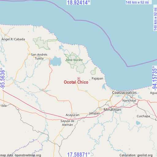
Ocotal Chico GPS coordinates[2]
18° 15' 27.756" North, 94° 51' 37.692" West
| Map corner | latitude | longitude |
|---|---|---|
| Upper-left | 18.92414°, | -95.5636° |
| Center: | 18.25771°, | -94.86047° |
| Lower-right: | 17.58871°, | -94.15735° |
| Map W x H: | 148.5×148.5 km | = 92.3×92.3mi |
| max Lat: | 32.7° ⇑75.4% North |
| Ocotal Chico: | 18.25771° |
| min Lat: | ⇓24.6% South 14.53588° |
| min Long | Ocotal Chico | max Long |
| -117.105° | -94.86047° | -86.73105° |
| W 84.9%⇐ | ⇒15.1% E |
Elevation
Elevation of Ocotal Chico is 608 m = 1995 ft, and this is 645.7 m = 2118 ft below average elevation for this country.
| Max E: |
3497 m = 11473 ft | 66.6% |
| Avg. | 1253.7 m = 4113 ft | |
| Ocotal Chico | 608 m = 1995 ft | |
Min E: |
-1 m = -3 ft | 33.4% |
See also: Mexico elevation on elevation.city.
Geographical zone
Ocotal Chico is located in North Torrid zone (between Equator and Tropic of Cancer). Distance of this Northern Tropic circle is 575.9 km =357.8 mi to North.| Distance of | km | miles | from Ocotal Chico |
|---|---|---|---|
| North Pole | 7977 | 4956.7 | to North |
| Arctic Circle | 5371.1 | 3337.4 | to North |
| Tropic Cancer | 575.9 | 357.8 | to North |
| Equator | 2030.1 | 1261.4 | to South |


Nearby cities:
15 places around Ocotal Chico: (largest is in red/bold)
• Buenavista
8.3 km =5.2 mi,  246°
246°
• Cerro de la Palma
10.7 km =6.6 mi,  165°
165°
• Cuilonia Nuevo
12.8 km =8 mi,  206°
206°
• El Tulín
9.9 km =6.2 mi,  263°
263°
• Encino Amarillo
8 km =5 mi,  63°
63°
• Ixhuapán
11.2 km =7 mi,  144°
144°
• Las Palomas (Bajo Paloma)
13.1 km =8.1 mi,  199°
199°
• Loma de Sogotegoyo
12.7 km =7.9 mi, 250°
• Mecayapan
4.8 km =3 mi,  150°
150°
• Morelos
12.8 km =8 mi,  227°
227°
• Ocozotepec
5.3 km =3.3 mi,  271°
271°
• Saltillo
11 km =6.8 mi,  176°
176°
• San Fernando
2.9 km =1.8 mi,  296°
296°
• Soteapan
3 km =1.9 mi, 206°
• Tatahuicapan
10.6 km =6.6 mi,  96°
96°
Sources, notices
• [Note1] Compared only with cities in Mexico existing in our database
• [Src1] Map data: © OpenStreetMap contributors (CC-BY-SA)
• [Src2] Other city data from geonames.org with taken over terms of usage.
• [Src3] Geographical zone / Annual Mean Temperature by Robert A. Rohde @ Wikipedia
