Mecayapan geodata
Mecayapan (Veracruz) is a seat of a second-order administrative division; located in Mexico in America/Mexico_City (GMT-6) time zone. With population of 6,068 people, there are 1538 cities with bigger population in this country. Compared to other cities in Mexico, 75.9% of cities are located further ↑North; 84.9% of cities are located further ←West and 71.5% of cities have higher elevation than Mecayapan. Note1


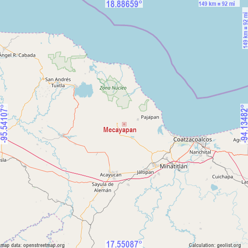
Mecayapan GPS coordinates[2]
18° 13' 12.036" North, 94° 50' 16.584" West
| Map corner | latitude | longitude |
|---|---|---|
| Upper-left | 18.88659°, | -95.54107° |
| Center: | 18.22001°, | -94.83794° |
| Lower-right: | 17.55087°, | -94.13482° |
| Map W x H: | 148.5×148.5 km | = 92.3×92.3mi |
| max Lat: | 32.7° ⇑75.9% North |
| Mecayapan: | 18.22001° |
| min Lat: | ⇓24.1% South 14.53588° |
| min Long | Mecayapan | max Long |
| -117.105° | -94.83794° | -86.73105° |
| W 84.9%⇐ | ⇒15.1% E |
Elevation
Elevation of Mecayapan is 347 m = 1138 ft, and this is 906.7 m = 2975 ft below average elevation for this country.
| Max E: |
3497 m = 11473 ft | 71.5% |
| Avg. | 1253.7 m = 4113 ft | |
| Mecayapan | 347 m = 1138 ft | |
Min E: |
-1 m = -3 ft | 28.5% |
See also: Mexico elevation on elevation.city.
Geographical zone
Mecayapan is located in North Torrid zone (between Equator and Tropic of Cancer). Distance of this Northern Tropic circle is 580 km =360.4 mi to North.| Distance of | km | miles | from Mecayapan |
|---|---|---|---|
| North Pole | 7981.2 | 4959.3 | to North |
| Arctic Circle | 5375.3 | 3340.1 | to North |
| Tropic Cancer | 580 | 360.4 | to North |
| Equator | 2025.9 | 1258.8 | to South |


Nearby cities:
15 places around Mecayapan: (largest is in red/bold)
• Amamaloya
8.5 km =5.3 mi,  158°
158°
• Buenavista
10.1 km =6.3 mi,  275°
275°
• Cerro de la Palma
6.2 km =3.9 mi,  177°
177°
• Cuilonia Nuevo
10.9 km =6.8 mi,  228°
228°
• Encino Amarillo
9.1 km =5.7 mi,  32°
32°
• Huazuntlán
8.5 km =5.3 mi,  146°
146°
• Ixhuapán
6.4 km =4 mi,  139°
139°
• Las Palomas (Bajo Paloma)
10.5 km =6.5 mi,  219°
219°
• Ocotal Chico
4.8 km =3 mi,  330°
330°
• Ocozotepec
8.8 km =5.5 mi,  299°
299°
• Saltillo
7 km =4.3 mi,  193°
193°
• San Fernando
7.4 km =4.6 mi,  317°
317°
• Soteapan
4 km =2.5 mi,  292°
292°
• Tatahuicapan
8.6 km =5.3 mi,  70°
70°
• Tonalapa
9.2 km =5.7 mi, 148°
Sources, notices
• [Note1] Compared only with cities in Mexico existing in our database
• [Src1] Map data: © OpenStreetMap contributors (CC-BY-SA)
• [Src2] Other city data from geonames.org with taken over terms of usage.
• [Src3] Geographical zone / Annual Mean Temperature by Robert A. Rohde @ Wikipedia
