Ixhuapán geodata
Ixhuapán (Veracruz) is a populated place; located in Mexico in America/Mexico_City (GMT-6) time zone. With population of 2,203 people, there are 3983 cities with bigger population in this country. Compared to other cities in Mexico, 76.5% of cities are located further ↑North; 85% of cities are located further ←West and 80.9% of cities have higher elevation than Ixhuapán. Note1


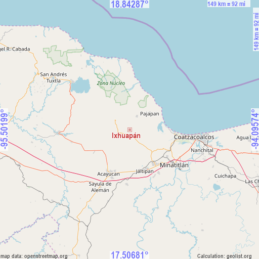
Ixhuapán GPS coordinates[2]
18° 10' 34.032" North, 94° 47' 55.896" West
| Map corner | latitude | longitude |
|---|---|---|
| Upper-left | 18.84287°, | -95.50199° |
| Center: | 18.17612°, | -94.79886° |
| Lower-right: | 17.50681°, | -94.09574° |
| Map W x H: | 148.6×148.6 km | = 92.3×92.3mi |
| max Lat: | 32.7° ⇑76.5% North |
| Ixhuapán: | 18.17612° |
| min Lat: | ⇓23.5% South 14.53588° |
| min Long | Ixhuapán | max Long |
| -117.105° | -94.79886° | -86.73105° |
| W 85%⇐ | ⇒15% E |
Elevation
Elevation of Ixhuapán is 84 m = 276 ft, and this is 1169.7 m = 3838 ft below average elevation for this country.
| Max E: |
3497 m = 11473 ft | 80.9% |
| Avg. | 1253.7 m = 4113 ft | |
| Ixhuapán | 84 m = 276 ft | |
Min E: |
-1 m = -3 ft | 19.1% |
See also: Mexico elevation on elevation.city.
Geographical zone
Ixhuapán is located in North Torrid zone (between Equator and Tropic of Cancer). Distance of this Northern Tropic circle is 584.9 km =363.4 mi to North.| Distance of | km | miles | from Ixhuapán |
|---|---|---|---|
| North Pole | 7986.1 | 4962.3 | to North |
| Arctic Circle | 5380.2 | 3343.1 | to North |
| Tropic Cancer | 584.9 | 363.4 | to North |
| Equator | 2021 | 1255.8 | to South |


Nearby cities:
15 places around Ixhuapán: (largest is in red/bold)
• Amamaloya
3.2 km =2 mi,  198°
198°
• Cerro de la Palma
4.1 km =2.5 mi,  251°
251°
• Cuilonia Nuevo
12.4 km =7.7 mi,  259°
259°
• El Naranjo
5.2 km =3.2 mi,  146°
146°
• Huazuntlán
2.2 km =1.4 mi,  164°
164°
• La Estribera
11.5 km =7.1 mi,  235°
235°
• Las Palomas (Bajo Paloma)
11.3 km =7 mi, 253°
• Mecayapan
6.4 km =4 mi,  319°
319°
• Minzapan
8.6 km =5.3 mi,  118°
118°
• Ocotal Chico
11.2 km =7 mi, 324°
• Saltillo
6.1 km =3.8 mi, 251°
• San Andrés Chamilpa
11 km =6.8 mi,  211°
211°
• Soteapan
10.1 km =6.3 mi,  309°
309°
• Tatahuicapan
8.7 km =5.4 mi,  27°
27°
• Tonalapa
3.1 km =1.9 mi,  167°
167°
Sources, notices
• [Note1] Compared only with cities in Mexico existing in our database
• [Src1] Map data: © OpenStreetMap contributors (CC-BY-SA)
• [Src2] Other city data from geonames.org with taken over terms of usage.
• [Src3] Geographical zone / Annual Mean Temperature by Robert A. Rohde @ Wikipedia
