Calkiní geodata
Calkiní (Campeche) is a seat of a second-order administrative division; located in Mexico in America/Merida (GMT-6) time zone. With population of 14,934 people, there are 646 cities with bigger population in this country. Compared to other cities in Mexico, 64.9% of cities are located further ↓South; 97.5% of cities are located further ←West and 94.6% of cities have higher elevation than Calkiní. Note1


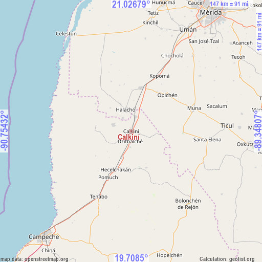
Calkiní GPS coordinates[2]
20° 22' 8.58" North, 90° 3' 4.284" West
| Map corner | latitude | longitude |
|---|---|---|
| Upper-left | 21.02679°, | -90.75432° |
| Center: | 20.36905°, | -90.05119° |
| Lower-right: | 19.7085°, | -89.34807° |
| Map W x H: | 146.6×146.6 km | = 91.1×91.1mi |
| max Lat: | 32.7° ⇑35.1% North |
| Calkiní: | 20.36905° |
| min Lat: | ⇓64.9% South 14.53588° |
| min Long | Calkiní | max Long |
| -117.105° | -90.05119° | -86.73105° |
| W 97.5%⇐ | ⇒2.5% E |
Elevation
Elevation of Calkiní is 14 m = 46 ft, and this is 1239.7 m = 4067 ft below average elevation for this country.
| Max E: |
3497 m = 11473 ft | 94.6% |
| Avg. | 1253.7 m = 4113 ft | |
| Calkiní | 14 m = 46 ft | |
Min E: |
-1 m = -3 ft | 5.4% |
See also: Mexico elevation on elevation.city.
Geographical zone
Calkiní is located in North Torrid zone (between Equator and Tropic of Cancer). Distance of this Northern Tropic circle is 341.1 km =211.9 mi to North.| Distance of | km | miles | from Calkiní |
|---|---|---|---|
| North Pole | 7742.2 | 4810.8 | to North |
| Arctic Circle | 5136.3 | 3191.5 | to North |
| Tropic Cancer | 341.1 | 211.9 | to North |
| Equator | 2264.8 | 1407.3 | to South |


Nearby cities:
15 places around Calkiní: (largest is in red/bold)
• Bacabchén
8.9 km =5.5 mi,  183°
183°
• Bécal
8.5 km =5.3 mi,  17°
17°
• Cepeda
16.4 km =10.2 mi,  338°
338°
• Cuch Holoch
8.7 km =5.4 mi,  326°
326°
• Dzitbalché
5.6 km =3.5 mi,  185°
185°
• Dzitnup
21.4 km =13.3 mi,  195°
195°
• Halachó
12.5 km =7.8 mi,  345°
345°
• Nunkiní
10.7 km =6.6 mi,  289°
289°
• Pocboc
15.8 km =9.8 mi, 199°
• Pucnachén
17.4 km =10.8 mi,  268°
268°
• San Antonio Sahcabchén
11.4 km =7.1 mi,  232°
232°
• Santa Cruz
19.7 km =12.2 mi, 200°
• Santa Cruz Ex-Hacienda
20 km =12.4 mi,  278°
278°
• Santa Cruz Pueblo
6.7 km =4.2 mi, 234°
• Tepakán
3.3 km =2.1 mi, 19°
Sources, notices
• [Note1] Compared only with cities in Mexico existing in our database
• [Src1] Map data: © OpenStreetMap contributors (CC-BY-SA)
• [Src2] Other city data from geonames.org with taken over terms of usage.
• [Src3] Geographical zone / Annual Mean Temperature by Robert A. Rohde @ Wikipedia
