Bacabchén geodata
Bacabchén (Campeche) is a populated place; located in Mexico in America/Merida (GMT-6) time zone. With population of 2,527 people, there are 3508 cities with bigger population in this country. Compared to other cities in Mexico, 63.3% of cities are located further ↓South; 97.5% of cities are located further ←West and 95.1% of cities have higher elevation than Bacabchén. Note1


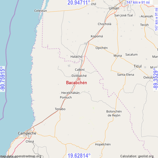
Bacabchén GPS coordinates[2]
20° 17' 20.508" North, 90° 3' 21.672" West
| Map corner | latitude | longitude |
|---|---|---|
| Upper-left | 20.94711°, | -90.75915° |
| Center: | 20.28903°, | -90.05602° |
| Lower-right: | 19.62814°, | -89.3529° |
| Map W x H: | 146.7×146.7 km | = 91.2×91.2mi |
| max Lat: | 32.7° ⇑36.7% North |
| Bacabchén: | 20.28903° |
| min Lat: | ⇓63.3% South 14.53588° |
| min Long | Bacabchén | max Long |
| -117.105° | -90.05602° | -86.73105° |
| W 97.5%⇐ | ⇒2.5% E |
Elevation
Elevation of Bacabchén is 13 m = 43 ft, and this is 1240.7 m = 4071 ft below average elevation for this country.
| Max E: |
3497 m = 11473 ft | 95.1% |
| Avg. | 1253.7 m = 4113 ft | |
| Bacabchén | 13 m = 43 ft | |
Min E: |
-1 m = -3 ft | 4.9% |
See also: Mexico elevation on elevation.city.
Geographical zone
Bacabchén is located in North Torrid zone (between Equator and Tropic of Cancer). Distance of this Northern Tropic circle is 350 km =217.5 mi to North.| Distance of | km | miles | from Bacabchén |
|---|---|---|---|
| North Pole | 7751.1 | 4816.3 | to North |
| Arctic Circle | 5145.2 | 3197.1 | to North |
| Tropic Cancer | 350 | 217.5 | to North |
| Equator | 2255.9 | 1401.8 | to South |


Nearby cities:
15 places around Bacabchén: (largest is in red/bold)
• Bécal
17.2 km =10.7 mi,  9°
9°
• Calkiní
8.9 km =5.5 mi,  3°
3°
• Chunkanán
20 km =12.4 mi,  255°
255°
• Cuch Holoch
16.7 km =10.4 mi,  345°
345°
• Cumpich
14.5 km =9 mi,  142°
142°
• Dzitbalché
3.3 km =2.1 mi,  359°
359°
• Dzitnup
12.8 km =8 mi,  204°
204°
• Hecelchakán
14.8 km =9.2 mi,  213°
213°
• Nunkiní
15.7 km =9.8 mi,  322°
322°
• Pocboc
7.7 km =4.8 mi,  218°
218°
• Pucnachén
18.9 km =11.7 mi,  296°
296°
• San Antonio Sahcabchén
8.8 km =5.5 mi,  283°
283°
• Santa Cruz
11.5 km =7.1 mi, 214°
• Santa Cruz Pueblo
7 km =4.3 mi, 315°
• Tepakán
12.1 km =7.5 mi, 7°
Sources, notices
• [Note1] Compared only with cities in Mexico existing in our database
• [Src1] Map data: © OpenStreetMap contributors (CC-BY-SA)
• [Src2] Other city data from geonames.org with taken over terms of usage.
• [Src3] Geographical zone / Annual Mean Temperature by Robert A. Rohde @ Wikipedia
