Nuevo Matzám geodata
Nuevo Matzám (Chiapas) is a populated place; located in Mexico in America/Mexico_City (GMT-6) time zone. With population of 502 people, there are 16762 cities with bigger population in this country. Compared to other cities in Mexico, 96.8% of cities are located further ↑North; 96.5% of cities are located further ←West and 71% of cities have higher elevation than Nuevo Matzám. Note1


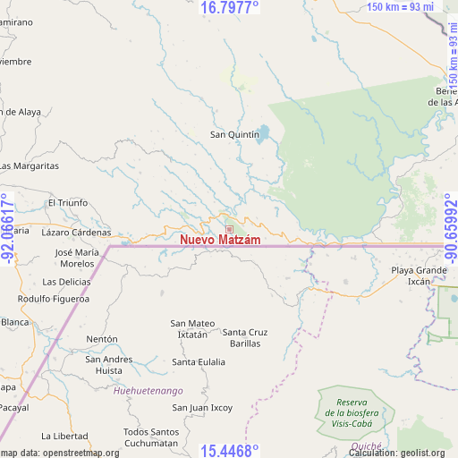
Nuevo Matzám GPS coordinates[2]
16° 7' 24.24" North, 91° 21' 46.944" West
| Map corner | latitude | longitude |
|---|---|---|
| Upper-left | 16.7977°, | -92.06617° |
| Center: | 16.1234°, | -91.36304° |
| Lower-right: | 15.4468°, | -90.65992° |
| Map W x H: | 150.2×150.2 km | = 93.3×93.3mi |
| max Lat: | 32.7° ⇑96.8% North |
| Nuevo Matzám: | 16.1234° |
| min Lat: | ⇓3.2% South 14.53588° |
| min Long | Nuevo Matzám | max Long |
| -117.105° | -91.36304° | -86.73105° |
| W 96.5%⇐ | ⇒3.5% E |
Elevation
Elevation of Nuevo Matzám is 369 m = 1211 ft, and this is 884.7 m = 2903 ft below average elevation for this country.
| Max E: |
3497 m = 11473 ft | 71% |
| Avg. | 1253.7 m = 4113 ft | |
| Nuevo Matzám | 369 m = 1211 ft | |
Min E: |
-1 m = -3 ft | 29% |
See also: Mexico elevation on elevation.city.
Geographical zone
Nuevo Matzám is located in North Torrid zone (between Equator and Tropic of Cancer). Distance of this Northern Tropic circle is 813.2 km =505.3 mi to North.| Distance of | km | miles | from Nuevo Matzám |
|---|---|---|---|
| North Pole | 8214.3 | 5104.1 | to North |
| Arctic Circle | 5608.4 | 3484.9 | to North |
| Tropic Cancer | 813.2 | 505.3 | to North |
| Equator | 1792.8 | 1114 | to South |


Nearby cities:
15 places around Nuevo Matzám: (largest is in red/bold)
• Amparo Agua Tinta
13.7 km =8.5 mi,  275°
275°
• Guadalupe Miramar
9.7 km =6 mi,  66°
66°
• Jerusalén
6.5 km =4 mi,  344°
344°
• Maravilla Tenejapa
7.4 km =4.6 mi, 74°
• Nueva Sabanilla
21.8 km =13.5 mi,  43°
43°
• Nuevo Huixtán
6.5 km =4 mi,  303°
303°
• Nuevo Poza Rica
6.7 km =4.2 mi,  312°
312°
• Nuevo Rodulfo Figueroa
15.3 km =9.5 mi, 44°
• Nuevo San Juan Chamula
8.9 km =5.5 mi,  285°
285°
• Nuevo Santo Tomás
10.2 km =6.3 mi,  330°
330°
• Playa Azul
27 km =16.8 mi, 284°
• San Antonio los Montes
17.8 km =11.1 mi, 302°
• San Isidro el Zapotal
27.1 km =16.8 mi, 278°
• San Pedro Yutniotic
4.8 km =3 mi,  211°
211°
• Santo Domingo de las Palmas
4.6 km =2.9 mi, 71°
Sources, notices
• [Note1] Compared only with cities in Mexico existing in our database
• [Src1] Map data: © OpenStreetMap contributors (CC-BY-SA)
• [Src2] Other city data from geonames.org with taken over terms of usage.
• [Src3] Geographical zone / Annual Mean Temperature by Robert A. Rohde @ Wikipedia
