Nuevo Poza Rica geodata
Nuevo Poza Rica (Chiapas) is a populated place; located in Mexico in America/Mexico_City (GMT-6) time zone. With population of 932 people, there are 9352 cities with bigger population in this country. Compared to other cities in Mexico, 96.5% of cities are located further ↑North; 96.4% of cities are located further ←West and 70.7% of cities have higher elevation than Nuevo Poza Rica. Note1


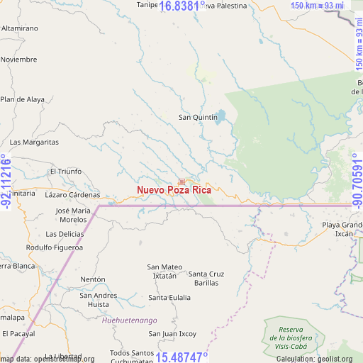
Nuevo Poza Rica GPS coordinates[2]
16° 9' 50.184" North, 91° 24' 32.508" West
| Map corner | latitude | longitude |
|---|---|---|
| Upper-left | 16.8381°, | -92.11216° |
| Center: | 16.16394°, | -91.40903° |
| Lower-right: | 15.48747°, | -90.70591° |
| Map W x H: | 150.2×150.2 km | = 93.3×93.3mi |
| max Lat: | 32.7° ⇑96.5% North |
| Nuevo Poza Rica: | 16.16394° |
| min Lat: | ⇓3.5% South 14.53588° |
| min Long | Nuevo Poza Rica | max Long |
| -117.105° | -91.40903° | -86.73105° |
| W 96.4%⇐ | ⇒3.6% E |
Elevation
Elevation of Nuevo Poza Rica is 381 m = 1250 ft, and this is 872.7 m = 2863 ft below average elevation for this country.
| Max E: |
3497 m = 11473 ft | 70.7% |
| Avg. | 1253.7 m = 4113 ft | |
| Nuevo Poza Rica | 381 m = 1250 ft | |
Min E: |
-1 m = -3 ft | 29.3% |
See also: Mexico elevation on elevation.city.
Geographical zone
Nuevo Poza Rica is located in North Torrid zone (between Equator and Tropic of Cancer). Distance of this Northern Tropic circle is 808.7 km =502.5 mi to North.| Distance of | km | miles | from Nuevo Poza Rica |
|---|---|---|---|
| North Pole | 8209.8 | 5101.3 | to North |
| Arctic Circle | 5603.9 | 3482.1 | to North |
| Tropic Cancer | 808.7 | 502.5 | to North |
| Equator | 1797.3 | 1116.8 | to South |


Nearby cities:
15 places around Nuevo Poza Rica: (largest is in red/bold)
• Amparo Agua Tinta
9.3 km =5.8 mi,  249°
249°
• Guadalupe Miramar
13.8 km =8.6 mi,  92°
92°
• Jerusalén
3.6 km =2.2 mi,  60°
60°
• Maravilla Tenejapa
12.3 km =7.6 mi,  101°
101°
• Nuevo Huixtán
1 km =0.6 mi,  208°
208°
• Nuevo Matzám
6.7 km =4.2 mi,  132°
132°
• Nuevo Rodulfo Figueroa
17 km =10.6 mi,  67°
67°
• Nuevo San Juan Chamula
4.3 km =2.7 mi,  239°
239°
• Nuevo Santo Tomás
4.4 km =2.7 mi,  358°
358°
• Playa Azul
21.4 km =13.3 mi,  275°
275°
• San Agustín
22.1 km =13.7 mi,  291°
291°
• San Antonio los Montes
11.3 km =7 mi,  296°
296°
• San Isidro el Zapotal
21.9 km =13.6 mi,  268°
268°
• San Pedro Yutniotic
8.9 km =5.5 mi,  164°
164°
• Santo Domingo de las Palmas
9.8 km =6.1 mi,  108°
108°
Sources, notices
• [Note1] Compared only with cities in Mexico existing in our database
• [Src1] Map data: © OpenStreetMap contributors (CC-BY-SA)
• [Src2] Other city data from geonames.org with taken over terms of usage.
• [Src3] Geographical zone / Annual Mean Temperature by Robert A. Rohde @ Wikipedia
