Nuevo San Juan Chamula geodata
Nuevo San Juan Chamula (Chiapas) is a populated place; located in Mexico in America/Mexico_City (GMT-6) time zone. With population of 1,684 people, there are 5157 cities with bigger population in this country. Compared to other cities in Mexico, 96.6% of cities are located further ↑North; 96.4% of cities are located further ←West and 68.9% of cities have higher elevation than Nuevo San Juan Chamula. Note1
Current local time in Nuevo San Juan Chamula:
05:31 AM, WednesdayDifference from your time zone: hours


Nuevo San Juan Chamula GPS coordinates[2]
16° 8' 39.336" North, 91° 26' 37.644" West
| Map corner | latitude | longitude |
|---|---|---|
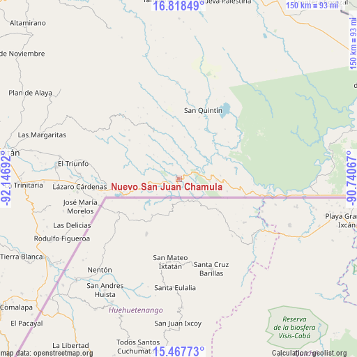
| Upper-left | 16.81849°, | -92.14692° |
| Center: | 16.14426°, | -91.44379° |
| Lower-right: | 15.46773°, | -90.74067° |
| Map W x H: | 150.2×150.2 km | = 93.3×93.3mi |
| max Lat: | 32.7° ⇑96.6% North |
| Nuevo San Juan Chamula: | 16.14426° |
| min Lat: | ⇓3.4% South 14.53588° |
| min Long | Nuevo San Juan | max Long |
| -117.105° | -91.44379° | -86.73105° |
| W 96.4%⇐ | ⇒3.6% E |
Elevation
Elevation of Nuevo San Juan Chamula is 474 m = 1555 ft, and this is 779.7 m = 2558 ft below average elevation for this country.
| Max E: |
3497 m = 11473 ft | 68.9% |
| Avg. | 1253.7 m = 4113 ft | |
| Nuevo San Juan Chamula | 474 m = 1555 ft | |
Min E: |
-1 m = -3 ft | 31.1% |
See also: Mexico elevation on elevation.city.
Geographical zone
Nuevo San Juan Chamula is located in North Torrid zone (between Equator and Tropic of Cancer). Distance of this Northern Tropic circle is 810.8 km =503.8 mi to North.| Distance of | km | miles | from Nuevo San Juan Chamula |
|---|---|---|---|
| North Pole | 8212 | 5102.7 | to North |
| Arctic Circle | 5606.1 | 3483.5 | to North |
| Tropic Cancer | 810.8 | 503.8 | to North |
| Equator | 1795.1 | 1115.4 | to South |


Nearby cities:
15 places around Nuevo San Juan Chamula: (largest is in red/bold)
• Amparo Agua Tinta
5.1 km =3.2 mi,  258°
258°
• Cuauhtémoc
18.9 km =11.7 mi, 258°
• Guadalupe Miramar
17.5 km =10.9 mi,  84°
84°
• Jerusalén
7.9 km =4.9 mi,  60°
60°
• Maravilla Tenejapa
15.8 km =9.8 mi,  91°
91°
• Nuevo Huixtán
3.5 km =2.2 mi,  68°
68°
• Nuevo Matzám
8.9 km =5.5 mi,  105°
105°
• Nuevo Poza Rica
4.3 km =2.7 mi, 59°
• Nuevo Santo Tomás
7.5 km =4.7 mi,  28°
28°
• Playa Azul
18 km =11.2 mi,  283°
283°
• San Agustín
19.8 km =12.3 mi,  301°
301°
• San Antonio los Montes
9.7 km =6 mi,  318°
318°
• San Isidro el Zapotal
18.3 km =11.4 mi,  274°
274°
• San Pedro Yutniotic
8.8 km =5.5 mi,  136°
136°
• Santo Domingo de las Palmas
13 km =8.1 mi, 93°
Sources, notices
• [Note1] Compared only with cities in Mexico existing in our database
• [Src1] Map data: © OpenStreetMap contributors (CC-BY-SA)
• [Src2] Other city data from geonames.org with taken over terms of usage.
• [Src3] Geographical zone / Annual Mean Temperature by Robert A. Rohde @ Wikipedia
