Guadalupe Miramar geodata
Guadalupe Miramar (Chiapas) is a populated place; located in Mexico in America/Mexico_City (GMT-6) time zone. With population of 535 people, there are 15842 cities with bigger population in this country. Compared to other cities in Mexico, 96.6% of cities are located further ↑North; 96.6% of cities are located further ←West and 70.1% of cities have higher elevation than Guadalupe Miramar. Note1


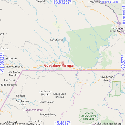
Guadalupe Miramar GPS coordinates[2]
16° 9' 29.484" North, 91° 16' 48.432" West
| Map corner | latitude | longitude |
|---|---|---|
| Upper-left | 16.83237°, | -91.98325° |
| Center: | 16.15819°, | -91.28012° |
| Lower-right: | 15.4817°, | -90.577° |
| Map W x H: | 150.2×150.2 km | = 93.3×93.3mi |
| max Lat: | 32.7° ⇑96.6% North |
| Guadalupe Miramar: | 16.15819° |
| min Lat: | ⇓3.4% South 14.53588° |
| min Long | Guadalupe Miram | max Long |
| -117.105° | -91.28012° | -86.73105° |
| W 96.6%⇐ | ⇒3.4% E |
Elevation
Elevation of Guadalupe Miramar is 413 m = 1355 ft, and this is 840.7 m = 2758 ft below average elevation for this country.
| Max E: |
3497 m = 11473 ft | 70.1% |
| Avg. | 1253.7 m = 4113 ft | |
| Guadalupe Miramar | 413 m = 1355 ft | |
Min E: |
-1 m = -3 ft | 29.9% |
See also: Mexico elevation on elevation.city.
Geographical zone
Guadalupe Miramar is located in North Torrid zone (between Equator and Tropic of Cancer). Distance of this Northern Tropic circle is 809.3 km =502.9 mi to North.| Distance of | km | miles | from Guadalupe Miramar |
|---|---|---|---|
| North Pole | 8210.4 | 5101.7 | to North |
| Arctic Circle | 5604.6 | 3482.5 | to North |
| Tropic Cancer | 809.3 | 502.9 | to North |
| Equator | 1796.6 | 1116.4 | to South |


Nearby cities:
15 places around Guadalupe Miramar: (largest is in red/bold)
• Amparo Agua Tinta
22.6 km =14 mi,  263°
263°
• El Ixcán
21.5 km =13.4 mi,  111°
111°
• Jerusalén
10.9 km =6.8 mi,  282°
282°
• Maravilla Tenejapa
2.5 km =1.6 mi,  222°
222°
• Nueva Providencia
26.1 km =16.2 mi,  340°
340°
• Nueva Sabanilla
13.4 km =8.3 mi,  27°
27°
• Nuevo Huixtán
14.2 km =8.8 mi,  269°
269°
• Nuevo Matzám
9.7 km =6 mi,  246°
246°
• Nuevo Poza Rica
13.8 km =8.6 mi, 272°
• Nuevo Rodulfo Figueroa
7.3 km =4.5 mi,  15°
15°
• Nuevo San Juan Chamula
17.5 km =10.9 mi, 264°
• Nuevo Santo Tomás
14.8 km =9.2 mi,  289°
289°
• San Antonio los Montes
24.6 km =15.3 mi, 283°
• San Pedro Yutniotic
13.9 km =8.6 mi,  235°
235°
• Santo Domingo de las Palmas
5.1 km =3.2 mi, 241°
Sources, notices
• [Note1] Compared only with cities in Mexico existing in our database
• [Src1] Map data: © OpenStreetMap contributors (CC-BY-SA)
• [Src2] Other city data from geonames.org with taken over terms of usage.
• [Src3] Geographical zone / Annual Mean Temperature by Robert A. Rohde @ Wikipedia
