Nueva Independencia geodata
Nueva Independencia (Chiapas) is a populated place; located in Mexico in America/Mexico_City (GMT-6) time zone. With population of 2,001 people, there are 4348 cities with bigger population in this country. Compared to other cities in Mexico, 97.9% of cities are located further ↑North; 94.1% of cities are located further ←West and 64.7% of cities have higher elevation than Nueva Independencia. Note1


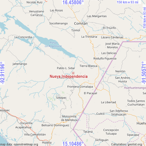
Nueva Independencia GPS coordinates[2]
15° 46' 57.324" North, 92° 12' 31.788" West
| Map corner | latitude | longitude |
|---|---|---|
| Upper-left | 16.45806°, | -92.91196° |
| Center: | 15.78259°, | -92.20883° |
| Lower-right: | 15.10486°, | -91.50571° |
| Map W x H: | 150.5×150.5 km | = 93.5×93.5mi |
| max Lat: | 32.7° ⇑97.9% North |
| Nueva Independencia: | 15.78259° |
| min Lat: | ⇓2.1% South 14.53588° |
| min Long | Nueva Independe | max Long |
| -117.105° | -92.20883° | -86.73105° |
| W 94.1%⇐ | ⇒5.9% E |
Elevation
Elevation of Nueva Independencia is 706 m = 2316 ft, and this is 547.7 m = 1797 ft below average elevation for this country.
| Max E: |
3497 m = 11473 ft | 64.7% |
| Avg. | 1253.7 m = 4113 ft | |
| Nueva Independencia | 706 m = 2316 ft | |
Min E: |
-1 m = -3 ft | 35.3% |
See also: Mexico elevation on elevation.city.
Geographical zone
Nueva Independencia is located in North Torrid zone (between Equator and Tropic of Cancer). Distance of this Northern Tropic circle is 851.1 km =528.8 mi to North.| Distance of | km | miles | from Nueva Independencia |
|---|---|---|---|
| North Pole | 8252.2 | 5127.7 | to North |
| Arctic Circle | 5646.3 | 3508.4 | to North |
| Tropic Cancer | 851.1 | 528.8 | to North |
| Equator | 1754.9 | 1090.4 | to South |


Nearby cities:
15 places around Nueva Independencia: (largest is in red/bold)
• Benito Juárez
4.6 km =2.9 mi,  4°
4°
• Chicomuselo
9 km =5.6 mi,  241°
241°
• Costa Rica
7.2 km =4.5 mi,  118°
118°
• El Anonal
13.5 km =8.4 mi,  140°
140°
• Emiliano Zapata
13 km =8.1 mi,  194°
194°
• Guadalupe Grijalva
10.5 km =6.5 mi,  152°
152°
• La Reforma
8.2 km =5.1 mi,  178°
178°
• La Sabinada
11.7 km =7.3 mi, 149°
• Las Chicharras
12.4 km =7.7 mi, 180°
• Lázaro Cárdenas
8.8 km =5.5 mi,  213°
213°
• Nueva Libertad
3 km =1.9 mi,  164°
164°
• Nuevo Mazapa
7.4 km =4.6 mi,  96°
96°
• Pablo L. Sidar
9.3 km =5.8 mi,  305°
305°
• Santa Rosa
13 km =8.1 mi, 120°
• Veinticuatro de Febrero
8.3 km =5.2 mi, 161°
Sources, notices
• [Note1] Compared only with cities in Mexico existing in our database
• [Src1] Map data: © OpenStreetMap contributors (CC-BY-SA)
• [Src2] Other city data from geonames.org with taken over terms of usage.
• [Src3] Geographical zone / Annual Mean Temperature by Robert A. Rohde @ Wikipedia
