Lázaro Cárdenas geodata
Lázaro Cárdenas (Chiapas) is a populated place; located in Mexico in America/Mexico_City (GMT-6) time zone. With population of 1,321 people, there are 6568 cities with bigger population in this country. Compared to other cities in Mexico, 98.1% of cities are located further ↑North; 93.7% of cities are located further ←West and 66.5% of cities have higher elevation than Lázaro Cárdenas. Note1


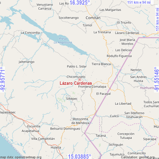
Lázaro Cárdenas GPS coordinates[2]
15° 43' 0.48" North, 92° 15' 16.488" West
| Map corner | latitude | longitude |
|---|---|---|
| Upper-left | 16.3925°, | -92.95771° |
| Center: | 15.7168°, | -92.25458° |
| Lower-right: | 15.03885°, | -91.55146° |
| Map W x H: | 150.5×150.5 km | = 93.5×93.5mi |
| max Lat: | 32.7° ⇑98.1% North |
| Lázaro Cárdenas: | 15.7168° |
| min Lat: | ⇓1.9% South 14.53588° |
| min Long | Lázaro Cárden | max Long |
| -117.105° | -92.25458° | -86.73105° |
| W 93.7%⇐ | ⇒6.3% E |
Elevation
Elevation of Lázaro Cárdenas is 610 m = 2001 ft, and this is 643.7 m = 2112 ft below average elevation for this country.
| Max E: |
3497 m = 11473 ft | 66.5% |
| Avg. | 1253.7 m = 4113 ft | |
| Lázaro Cárdenas | 610 m = 2001 ft | |
Min E: |
-1 m = -3 ft | 33.5% |
See also: Mexico elevation on elevation.city.
Geographical zone
Lázaro Cárdenas is located in North Torrid zone (between Equator and Tropic of Cancer). Distance of this Northern Tropic circle is 858.4 km =533.4 mi to North.| Distance of | km | miles | from Lázaro Cárdenas |
|---|---|---|---|
| North Pole | 8259.5 | 5132.2 | to North |
| Arctic Circle | 5653.6 | 3513 | to North |
| Tropic Cancer | 858.4 | 533.4 | to North |
| Equator | 1747.5 | 1085.8 | to South |


Nearby cities:
15 places around Lázaro Cárdenas: (largest is in red/bold)
• Bellavista del Norte
11.7 km =7.3 mi,  118°
118°
• Chicomuselo
4.3 km =2.7 mi,  314°
314°
• Emiliano Zapata
5.6 km =3.5 mi,  162°
162°
• Guadalupe Grijalva
9.9 km =6.2 mi,  101°
101°
• La Hacienda
7.9 km =4.9 mi,  200°
200°
• La Reforma
5.2 km =3.2 mi, 99°
• La Sabinada
11.2 km =7 mi, 104°
• La Zacualpa
6.5 km =4 mi,  245°
245°
• Las Chicharras
6.9 km =4.3 mi,  137°
137°
• Nueva Independencia
8.8 km =5.5 mi,  33°
33°
• Nueva Libertad
7.2 km =4.5 mi,  52°
52°
• Nuevo Pacayal
9.1 km =5.7 mi,  225°
225°
• Piedra Labrada
6.7 km =4.2 mi, 234°
• San José las Chicharras
9.6 km =6 mi,  147°
147°
• Veinticuatro de Febrero
7.5 km =4.7 mi,  94°
94°
Sources, notices
• [Note1] Compared only with cities in Mexico existing in our database
• [Src1] Map data: © OpenStreetMap contributors (CC-BY-SA)
• [Src2] Other city data from geonames.org with taken over terms of usage.
• [Src3] Geographical zone / Annual Mean Temperature by Robert A. Rohde @ Wikipedia
