Nueva Costa Rica geodata
Nueva Costa Rica (Chiapas) is a populated place; located in Mexico in America/Mexico_City (GMT-6) time zone. With population of 566 people, there are 15096 cities with bigger population in this country. Compared to other cities in Mexico, 98.6% of cities are located further ↑North; 89.7% of cities are located further ←West and 72.5% of cities have higher elevation than Nueva Costa Rica. Note1


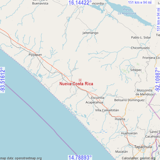
Nueva Costa Rica GPS coordinates[2]
15° 28' 3.648" North, 92° 48' 46.764" West
| Map corner | latitude | longitude |
|---|---|---|
| Upper-left | 16.14422°, | -93.51612° |
| Center: | 15.46768°, | -92.81299° |
| Lower-right: | 14.78893°, | -92.10987° |
| Map W x H: | 150.7×150.7 km | = 93.6×93.6mi |
| max Lat: | 32.7° ⇑98.6% North |
| Nueva Costa Rica: | 15.46768° |
| min Lat: | ⇓1.4% South 14.53588° |
| min Long | Nueva Costa Ric | max Long |
| -117.105° | -92.81299° | -86.73105° |
| W 89.7%⇐ | ⇒10.3% E |
Elevation
Elevation of Nueva Costa Rica is 311 m = 1020 ft, and this is 942.7 m = 3093 ft below average elevation for this country.
| Max E: |
3497 m = 11473 ft | 72.5% |
| Avg. | 1253.7 m = 4113 ft | |
| Nueva Costa Rica | 311 m = 1020 ft | |
Min E: |
-1 m = -3 ft | 27.5% |
See also: Mexico elevation on elevation.city.
Geographical zone
Nueva Costa Rica is located in North Torrid zone (between Equator and Tropic of Cancer). Distance of this Northern Tropic circle is 886.1 km =550.6 mi to North.| Distance of | km | miles | from Nueva Costa Rica |
|---|---|---|---|
| North Pole | 8287.2 | 5149.4 | to North |
| Arctic Circle | 5681.3 | 3530.2 | to North |
| Tropic Cancer | 886.1 | 550.6 | to North |
| Equator | 1719.8 | 1068.6 | to South |


Nearby cities:
15 places around Nueva Costa Rica: (largest is in red/bold)
• Abraham González
14.7 km =9.1 mi,  219°
219°
• Doctor Samuel León Brindis
17.5 km =10.9 mi,  284°
284°
• El Consuelo Ulapa
9.3 km =5.8 mi,  166°
166°
• Flores Magón
7 km =4.3 mi,  201°
201°
• Generación 2000 Nuevo Milenio
8.6 km =5.3 mi,  269°
269°
• Guadalupe Victoria
8.2 km =5.1 mi,  300°
300°
• Hidalgo
15.2 km =9.4 mi,  149°
149°
• Jiquilpan
16 km =9.9 mi,  176°
176°
• Jiquilpan (Estación Bonanza)
15.6 km =9.7 mi, 153°
• La Alianza
12.4 km =7.7 mi,  210°
210°
• Mapastepec
10.1 km =6.3 mi,  247°
247°
• Nicolás Bravo Dos Anexo Emiliano Zapata
15.2 km =9.4 mi,  193°
193°
• Nueva Libertad
13.3 km =8.3 mi,  120°
120°
• Nueva Sesecapa
7.4 km =4.6 mi, 187°
• Nuevo Milenio Valdivia
15.1 km =9.4 mi,  285°
285°
Sources, notices
• [Note1] Compared only with cities in Mexico existing in our database
• [Src1] Map data: © OpenStreetMap contributors (CC-BY-SA)
• [Src2] Other city data from geonames.org with taken over terms of usage.
• [Src3] Geographical zone / Annual Mean Temperature by Robert A. Rohde @ Wikipedia
