Abraham González geodata
Abraham González (Chiapas) is a populated place; located in Mexico in America/Mexico_City (GMT-6) time zone. With population of 658 people, there are 13187 cities with bigger population in this country. Compared to other cities in Mexico, 98.7% of cities are located further ↑North; 89.2% of cities are located further ←West and 91.2% of cities have higher elevation than Abraham González. Note1


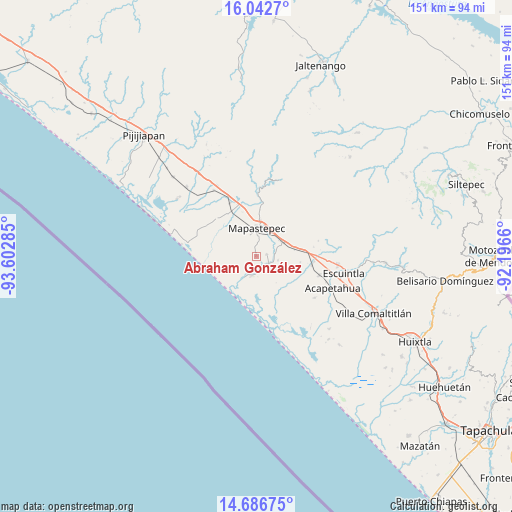
Abraham González GPS coordinates[2]
15° 21' 56.988" North, 92° 53' 58.992" West
| Map corner | latitude | longitude |
|---|---|---|
| Upper-left | 16.0427°, | -93.60285° |
| Center: | 15.36583°, | -92.89972° |
| Lower-right: | 14.68675°, | -92.1966° |
| Map W x H: | 150.8×150.8 km | = 93.7×93.7mi |
| max Lat: | 32.7° ⇑98.7% North |
| Abraham González: | 15.36583° |
| min Lat: | ⇓1.3% South 14.53588° |
| min Long | Abraham Gonzál | max Long |
| -117.105° | -92.89972° | -86.73105° |
| W 89.2%⇐ | ⇒10.8% E |
Elevation
Elevation of Abraham González is 21 m = 69 ft, and this is 1232.7 m = 4044 ft below average elevation for this country.
| Max E: |
3497 m = 11473 ft | 91.2% |
| Avg. | 1253.7 m = 4113 ft | |
| Abraham González | 21 m = 69 ft | |
Min E: |
-1 m = -3 ft | 8.8% |
See also: Mexico elevation on elevation.city.
Geographical zone
Abraham González is located in North Torrid zone (between Equator and Tropic of Cancer). Distance of this Northern Tropic circle is 897.4 km =557.6 mi to North.| Distance of | km | miles | from Abraham González |
|---|---|---|---|
| North Pole | 8298.5 | 5156.4 | to North |
| Arctic Circle | 5692.7 | 3537.3 | to North |
| Tropic Cancer | 897.4 | 557.6 | to North |
| Equator | 1708.5 | 1061.6 | to South |


Nearby cities:
15 places around Abraham González: (largest is in red/bold)
• Adolfo López Mateos
16.2 km =10.1 mi,  313°
313°
• El Consuelo Ulapa
11.7 km =7.3 mi,  78°
78°
• Flores Magón
8.3 km =5.2 mi,  54°
54°
• Generación 2000 Nuevo Milenio
11.3 km =7 mi,  3°
3°
• Guadalupe Victoria
15.7 km =9.8 mi,  8°
8°
• Hidalgo
17 km =10.6 mi,  95°
95°
• Jiquilpan
11.2 km =7 mi,  114°
114°
• Jiquilpan (Estación Bonanza)
16.5 km =10.3 mi, 99°
• La Alianza
3.1 km =1.9 mi, 77°
• Mapastepec
7.5 km =4.7 mi,  359°
359°
• Nicolás Bravo Dos Anexo Emiliano Zapata
6.7 km =4.2 mi,  121°
121°
• Nueva Costa Rica
14.7 km =9.1 mi,  39°
39°
• Nueva Sesecapa
9.2 km =5.7 mi,  64°
64°
• Nuevo Milenio Valdivia
16.1 km =10 mi,  341°
341°
• Veinte de Abril
15.1 km =9.4 mi,  131°
131°
Sources, notices
• [Note1] Compared only with cities in Mexico existing in our database
• [Src1] Map data: © OpenStreetMap contributors (CC-BY-SA)
• [Src2] Other city data from geonames.org with taken over terms of usage.
• [Src3] Geographical zone / Annual Mean Temperature by Robert A. Rohde @ Wikipedia
