Flores Magón geodata
Flores Magón (Chiapas) is a populated place; located in Mexico in America/Mexico_City (GMT-6) time zone. With population of 592 people, there are 14508 cities with bigger population in this country. Compared to other cities in Mexico, 98.7% of cities are located further ↑North; 89.6% of cities are located further ←West and 85.9% of cities have higher elevation than Flores Magón. Note1


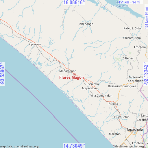
Flores Magón GPS coordinates[2]
15° 24' 33.948" North, 92° 50' 11.544" West
| Map corner | latitude | longitude |
|---|---|---|
| Upper-left | 16.08616°, | -93.53967° |
| Center: | 15.40943°, | -92.83654° |
| Lower-right: | 14.73049°, | -92.13342° |
| Map W x H: | 150.7×150.7 km | = 93.6×93.6mi |
| max Lat: | 32.7° ⇑98.7% North |
| Flores Magón: | 15.40943° |
| min Lat: | ⇓1.3% South 14.53588° |
| min Long | Flores Magón | max Long |
| -117.105° | -92.83654° | -86.73105° |
| W 89.6%⇐ | ⇒10.4% E |
Elevation
Elevation of Flores Magón is 39 m = 128 ft, and this is 1214.7 m = 3985 ft below average elevation for this country.
| Max E: |
3497 m = 11473 ft | 85.9% |
| Avg. | 1253.7 m = 4113 ft | |
| Flores Magón | 39 m = 128 ft | |
Min E: |
-1 m = -3 ft | 14.1% |
See also: Mexico elevation on elevation.city.
Geographical zone
Flores Magón is located in North Torrid zone (between Equator and Tropic of Cancer). Distance of this Northern Tropic circle is 892.6 km =554.6 mi to North.| Distance of | km | miles | from Flores Magón |
|---|---|---|---|
| North Pole | 8293.7 | 5153.5 | to North |
| Arctic Circle | 5687.8 | 3534.2 | to North |
| Tropic Cancer | 892.6 | 554.6 | to North |
| Equator | 1713.4 | 1064.7 | to South |


Nearby cities:
15 places around Flores Magón: (largest is in red/bold)
• Abraham González
8.3 km =5.2 mi,  234°
234°
• El Consuelo Ulapa
5.4 km =3.4 mi,  118°
118°
• Generación 2000 Nuevo Milenio
8.8 km =5.5 mi,  316°
316°
• Guadalupe Victoria
11.6 km =7.2 mi,  336°
336°
• Hidalgo
12.1 km =7.5 mi, 123°
• Jiquilpan
10.1 km =6.3 mi,  160°
160°
• Jiquilpan (Estación Bonanza)
12.1 km =7.5 mi,  128°
128°
• La Alianza
5.6 km =3.5 mi,  221°
221°
• Mapastepec
7.4 km =4.6 mi,  291°
291°
• Nicolás Bravo Dos Anexo Emiliano Zapata
8.4 km =5.2 mi,  187°
187°
• Nueva Costa Rica
7 km =4.3 mi,  21°
21°
• Nueva Libertad
14 km =8.7 mi,  91°
91°
• Nueva Sesecapa
1.7 km =1.1 mi, 118°
• Soconusco
15.8 km =9.8 mi, 131°
• Veinte de Abril
15.5 km =9.6 mi, 162°
Sources, notices
• [Note1] Compared only with cities in Mexico existing in our database
• [Src1] Map data: © OpenStreetMap contributors (CC-BY-SA)
• [Src2] Other city data from geonames.org with taken over terms of usage.
• [Src3] Geographical zone / Annual Mean Temperature by Robert A. Rohde @ Wikipedia
