Nauzontla geodata
Nauzontla (Puebla) is a populated place; located in Mexico in America/Mexico_City (GMT-6) time zone. With population of 1,204 people, there are 7219 cities with bigger population in this country. Compared to other cities in Mexico, 56.1% of cities are located further ↓South; 68.4% of cities are located further ←West and 50% of cities have lower elevation than Nauzontla. Note1


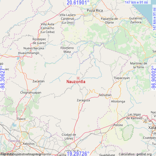
Nauzontla GPS coordinates[2]
19° 57' 34.272" North, 97° 36' 11.304" West
| Map corner | latitude | longitude |
|---|---|---|
| Upper-left | 20.61901°, | -98.30627° |
| Center: | 19.95952°, | -97.60314° |
| Lower-right: | 19.29726°, | -96.90002° |
| Map W x H: | 147×147 km | = 91.3×91.3mi |
| max Lat: | 32.7° ⇑43.9% North |
| Nauzontla: | 19.95952° |
| min Lat: | ⇓56.1% South 14.53588° |
| min Long | Nauzontla | max Long |
| -117.105° | -97.60314° | -86.73105° |
| W 68.4%⇐ | ⇒31.6% E |
Elevation
Elevation of Nauzontla is 1433 m = 4701 ft, and this is 179.3 m = 588 ft above average elevation for this country.
| Max E: |
3497 m = 11473 ft | 50% |
| Nauzontla | 1433 m 4701 ft | |
| Avg. | 1253.7 m = 4113 ft | |
Min E: |
-1 m = -3 ft | 50% |
See also: Mexico elevation on elevation.city.
Geographical zone
Nauzontla is located in North Torrid zone (between Equator and Tropic of Cancer). Distance of this Northern Tropic circle is 386.6 km =240.2 mi to North.| Distance of | km | miles | from Nauzontla |
|---|---|---|---|
| North Pole | 7787.8 | 4839.1 | to North |
| Arctic Circle | 5181.9 | 3219.9 | to North |
| Tropic Cancer | 386.6 | 240.2 | to North |
| Equator | 2219.3 | 1379 | to South |


Nearby cities:
15 places around Nauzontla: (largest is in red/bold)
• Atlequizayan
6.3 km =3.9 mi,  339°
339°
• Huahuaxtla
6 km =3.7 mi,  216°
216°
• Huapalegcan
6.8 km =4.2 mi,  263°
263°
• Ignacio Allende (Concepción)
6.6 km =4.1 mi,  330°
330°
• Pahuatla
7.3 km =4.5 mi,  252°
252°
• San Juan Tahitic
6.1 km =3.8 mi,  115°
115°
• San Martín
6.8 km =4.2 mi,  323°
323°
• San Miguel del Progreso
7.4 km =4.6 mi,  296°
296°
• San Rafael Axolota
2.2 km =1.4 mi,  190°
190°
• Tuxtla
7.1 km =4.4 mi,  309°
309°
• Xalacapan de Lucke
6.3 km =3.9 mi,  167°
167°
• Xilita
4.7 km =2.9 mi,  156°
156°
• Xochitepec
6.3 km =3.9 mi,  133°
133°
• Zoatecpan
3.3 km =2.1 mi,  212°
212°
• Zoquiopan
5.5 km =3.4 mi,  7°
7°
Sources, notices
• [Note1] Compared only with cities in Mexico existing in our database
• [Src1] Map data: © OpenStreetMap contributors (CC-BY-SA)
• [Src2] Other city data from geonames.org with taken over terms of usage.
• [Src3] Geographical zone / Annual Mean Temperature by Robert A. Rohde @ Wikipedia
