Huapalegcan geodata
Huapalegcan (Puebla) is a populated place; located in Mexico in America/Mexico_City (GMT-6) time zone. With population of 560 people, there are 15231 cities with bigger population in this country. Compared to other cities in Mexico, 56% of cities are located further ↓South; 67.7% of cities are located further ←West and 54.9% of cities have higher elevation than Huapalegcan. Note1


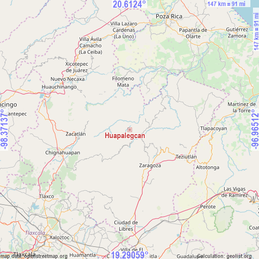
Huapalegcan GPS coordinates[2]
19° 57' 10.368" North, 97° 40' 5.664" West
| Map corner | latitude | longitude |
|---|---|---|
| Upper-left | 20.6124°, | -98.37137° |
| Center: | 19.95288°, | -97.66824° |
| Lower-right: | 19.29059°, | -96.96512° |
| Map W x H: | 147×147 km | = 91.3×91.3mi |
| max Lat: | 32.7° ⇑44% North |
| Huapalegcan: | 19.95288° |
| min Lat: | ⇓56% South 14.53588° |
| min Long | Huapalegcan | max Long |
| -117.105° | -97.66824° | -86.73105° |
| W 67.7%⇐ | ⇒32.3% E |
Elevation
Elevation of Huapalegcan is 1203 m = 3947 ft, and this is 50.7 m = 166 ft below average elevation for this country.
| Max E: |
3497 m = 11473 ft | 54.9% |
| Avg. | 1253.7 m = 4113 ft | |
| Huapalegcan | 1203 m = 3947 ft | |
Min E: |
-1 m = -3 ft | 45.1% |
See also: Mexico elevation on elevation.city.
Geographical zone
Huapalegcan is located in North Torrid zone (between Equator and Tropic of Cancer). Distance of this Northern Tropic circle is 387.4 km =240.7 mi to North.| Distance of | km | miles | from Huapalegcan |
|---|---|---|---|
| North Pole | 7788.5 | 4839.5 | to North |
| Arctic Circle | 5182.6 | 3220.3 | to North |
| Tropic Cancer | 387.4 | 240.7 | to North |
| Equator | 2218.6 | 1378.6 | to South |


Nearby cities:
15 places around Huapalegcan: (largest is in red/bold)
• Cuarta Sección
3.4 km =2.1 mi,  312°
312°
• Huahuaxtla
5.2 km =3.2 mi,  141°
141°
• Huitzilan
3.2 km =2 mi,  300°
300°
• Ignacio Allende (Concepción)
7.3 km =4.5 mi,  28°
28°
• Nanacatlán
5.7 km =3.5 mi,  351°
351°
• Nauzontla
6.8 km =4.2 mi,  83°
83°
• Pahuatla
1.4 km =0.9 mi,  186°
186°
• Primera Sección
2.7 km =1.7 mi,  292°
292°
• San Martín
6.7 km =4.2 mi,  24°
24°
• San Miguel del Progreso
4.1 km =2.5 mi,  2°
2°
• San Rafael Axolota
6.6 km =4.1 mi,  102°
102°
• Tuxtla
5.5 km =3.4 mi,  14°
14°
• Zoatecpan
5.4 km =3.4 mi,  112°
112°
• Zongozotla
6.9 km =4.3 mi, 295°
• Zoyotla
3.9 km =2.4 mi,  223°
223°
Sources, notices
• [Note1] Compared only with cities in Mexico existing in our database
• [Src1] Map data: © OpenStreetMap contributors (CC-BY-SA)
• [Src2] Other city data from geonames.org with taken over terms of usage.
• [Src3] Geographical zone / Annual Mean Temperature by Robert A. Rohde @ Wikipedia
