San Martín geodata
San Martín (Puebla) is a populated place; located in Mexico in America/Mexico_City (GMT-6) time zone. With population of 683 people, there are 12712 cities with bigger population in this country. Compared to other cities in Mexico, 57.2% of cities are located further ↓South; 68% of cities are located further ←West and 60.8% of cities have higher elevation than San Martín. Note1


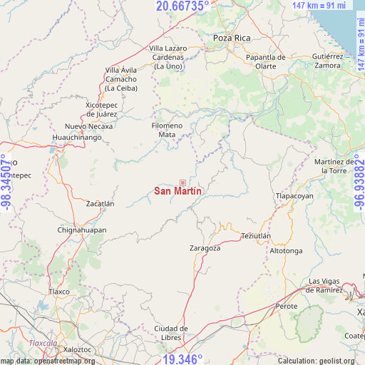
San Martín GPS coordinates[2]
20° 0' 29.016" North, 97° 38' 30.984" West
| Map corner | latitude | longitude |
|---|---|---|
| Upper-left | 20.66735°, | -98.34507° |
| Center: | 20.00806°, | -97.64194° |
| Lower-right: | 19.346°, | -96.93882° |
| Map W x H: | 146.9×146.9 km | = 91.3×91.3mi |
| max Lat: | 32.7° ⇑42.8% North |
| San Martín: | 20.00806° |
| min Lat: | ⇓57.2% South 14.53588° |
| min Long | San Martín | max Long |
| -117.105° | -97.64194° | -86.73105° |
| W 68%⇐ | ⇒32% E |
Elevation
Elevation of San Martín is 950 m = 3117 ft, and this is 303.7 m = 996 ft below average elevation for this country.
| Max E: |
3497 m = 11473 ft | 60.8% |
| Avg. | 1253.7 m = 4113 ft | |
| San Martín | 950 m = 3117 ft | |
Min E: |
-1 m = -3 ft | 39.2% |
See also: Mexico elevation on elevation.city.
Geographical zone
San Martín is located in North Torrid zone (between Equator and Tropic of Cancer). Distance of this Northern Tropic circle is 381.2 km =236.9 mi to North.| Distance of | km | miles | from San Martín |
|---|---|---|---|
| North Pole | 7782.4 | 4835.8 | to North |
| Arctic Circle | 5176.5 | 3216.5 | to North |
| Tropic Cancer | 381.2 | 236.9 | to North |
| Equator | 2224.7 | 1382.4 | to South |


Nearby cities:
15 places around San Martín: (largest is in red/bold)
• Atlequizayan
1.9 km =1.2 mi,  76°
76°
• Cuarta Sección
6.5 km =4 mi,  233°
233°
• Escatachuchut
5.3 km =3.3 mi,  5°
5°
• Huapalegcan
6.7 km =4.2 mi,  204°
204°
• Hueytlalpan
6.1 km =3.8 mi,  290°
290°
• Huitzilan
7.1 km =4.4 mi, 230°
• Ignacio Allende (Concepción)
0.8 km =0.5 mi,  70°
70°
• Ixtepec
1.9 km =1.2 mi,  346°
346°
• Nanacatlán
3.6 km =2.2 mi,  262°
262°
• Nauzontla
6.8 km =4.2 mi,  143°
143°
• Ozelonacaxtla
5.2 km =3.2 mi,  33°
33°
• San Miguel del Progreso
3.3 km =2.1 mi, 231°
• Tuxtla
1.6 km =1 mi,  238°
238°
• Zitlala
4.1 km =2.5 mi,  317°
317°
• Zoquiopan
4.8 km =3 mi,  88°
88°
Sources, notices
• [Note1] Compared only with cities in Mexico existing in our database
• [Src1] Map data: © OpenStreetMap contributors (CC-BY-SA)
• [Src2] Other city data from geonames.org with taken over terms of usage.
• [Src3] Geographical zone / Annual Mean Temperature by Robert A. Rohde @ Wikipedia
