Tuxtla geodata
Tuxtla (Puebla) is a populated place; located in Mexico in America/Mexico_City (GMT-6) time zone. With population of 2,466 people, there are 3586 cities with bigger population in this country. Compared to other cities in Mexico, 57% of cities are located further ↓South; 67.9% of cities are located further ←West and 61.5% of cities have higher elevation than Tuxtla. Note1


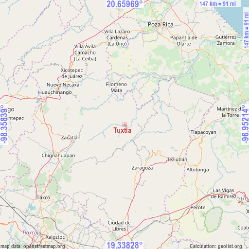
Tuxtla GPS coordinates[2]
20° 0' 1.332" North, 97° 39' 18.936" West
| Map corner | latitude | longitude |
|---|---|---|
| Upper-left | 20.65969°, | -98.35839° |
| Center: | 20.00037°, | -97.65526° |
| Lower-right: | 19.33828°, | -96.95214° |
| Map W x H: | 146.9×146.9 km | = 91.3×91.3mi |
| max Lat: | 32.7° ⇑43% North |
| Tuxtla: | 20.00037° |
| min Lat: | ⇓57% South 14.53588° |
| min Long | Tuxtla | max Long |
| -117.105° | -97.65526° | -86.73105° |
| W 67.9%⇐ | ⇒32.1% E |
Elevation
Elevation of Tuxtla is 908 m = 2979 ft, and this is 345.7 m = 1134 ft below average elevation for this country.
| Max E: |
3497 m = 11473 ft | 61.5% |
| Avg. | 1253.7 m = 4113 ft | |
| Tuxtla | 908 m = 2979 ft | |
Min E: |
-1 m = -3 ft | 38.5% |
See also: Mexico elevation on elevation.city.
Geographical zone
Tuxtla is located in North Torrid zone (between Equator and Tropic of Cancer). Distance of this Northern Tropic circle is 382.1 km =237.4 mi to North.| Distance of | km | miles | from Tuxtla |
|---|---|---|---|
| North Pole | 7783.2 | 4836.3 | to North |
| Arctic Circle | 5177.3 | 3217 | to North |
| Tropic Cancer | 382.1 | 237.4 | to North |
| Equator | 2223.8 | 1381.8 | to South |


Nearby cities:
15 places around Tuxtla: (largest is in red/bold)
• Atlequizayan
3.5 km =2.2 mi,  68°
68°
• Cuarta Sección
4.9 km =3 mi,  232°
232°
• Escatachuchut
6.4 km =4 mi,  17°
17°
• Huapalegcan
5.5 km =3.4 mi,  194°
194°
• Hueytlalpan
5.3 km =3.3 mi,  304°
304°
• Huitzilan
5.5 km =3.4 mi, 228°
• Ignacio Allende (Concepción)
2.4 km =1.5 mi,  62°
62°
• Ixtepec
2.9 km =1.8 mi, 19°
• Nanacatlán
2.2 km =1.4 mi,  279°
279°
• Primera Sección
5.8 km =3.6 mi,  222°
222°
• San Martín
1.6 km =1 mi, 58°
• San Miguel del Progreso
1.7 km =1.1 mi, 225°
• Zapotitlán
6.1 km =3.8 mi,  271°
271°
• Zitlala
4.1 km =2.5 mi,  340°
340°
• Zoquiopan
6.3 km =3.9 mi,  81°
81°
Sources, notices
• [Note1] Compared only with cities in Mexico existing in our database
• [Src1] Map data: © OpenStreetMap contributors (CC-BY-SA)
• [Src2] Other city data from geonames.org with taken over terms of usage.
• [Src3] Geographical zone / Annual Mean Temperature by Robert A. Rohde @ Wikipedia
