San Pedro Buenavista geodata
San Pedro Buenavista (Chiapas) is a populated place; located in Mexico in America/Mexico_City (GMT-6) time zone. With population of 8,390 people, there are 1135 cities with bigger population in this country. Compared to other cities in Mexico, 97% of cities are located further ↑North; 88% of cities are located further ←West and 66% of cities have higher elevation than San Pedro Buenavista. Note1
Current local time in San Pedro Buenavista:
06:46 AM, WednesdayDifference from your time zone: hours


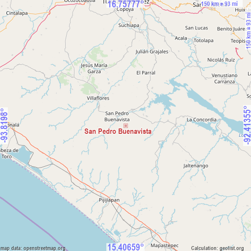
San Pedro Buenavista GPS coordinates[2]
16° 4' 59.988" North, 93° 7' 0.012" West
| Map corner | latitude | longitude |
|---|---|---|
| Upper-left | 16.75777°, | -93.8198° |
| Center: | 16.08333°, | -93.11667° |
| Lower-right: | 15.40659°, | -92.41355° |
| Map W x H: | 150.2×150.2 km | = 93.3×93.3mi |
| max Lat: | 32.7° ⇑97% North |
| San Pedro Buenavista: | 16.08333° |
| min Lat: | ⇓3% South 14.53588° |
| min Long | San Pedro Buena | max Long |
| -117.105° | -93.11667° | -86.73105° |
| W 88%⇐ | ⇒12% E |
Elevation
Elevation of San Pedro Buenavista is 636 m = 2087 ft, and this is 617.7 m = 2027 ft below average elevation for this country.
| Max E: |
3497 m = 11473 ft | 66% |
| Avg. | 1253.7 m = 4113 ft | |
| San Pedro Buenavista | 636 m = 2087 ft | |
Min E: |
-1 m = -3 ft | 34% |
See also: Mexico elevation on elevation.city.
Geographical zone
San Pedro Buenavista is located in North Torrid zone (between Equator and Tropic of Cancer). Distance of this Northern Tropic circle is 817.6 km =508 mi to North.| Distance of | km | miles | from San Pedro Buenavista |
|---|---|---|---|
| North Pole | 8218.8 | 5106.9 | to North |
| Arctic Circle | 5612.9 | 3487.7 | to North |
| Tropic Cancer | 817.6 | 508 | to North |
| Equator | 1788.3 | 1111.2 | to South |


Nearby cities:
15 places around San Pedro Buenavista: (largest is in red/bold)
• Diamante de Echeverría
25.6 km =15.9 mi,  82°
82°
• Dieciséis de Septiembre
24.6 km =15.3 mi,  345°
345°
• Embarcadero de Jericó (El Siglo)
23.3 km =14.5 mi,  55°
55°
• Emiliano Zapata
17.8 km =11.1 mi,  299°
299°
• Guadalupe Victoria
25 km =15.5 mi,  108°
108°
• Loma Bonita
20.7 km =12.9 mi,  48°
48°
• Manuel Ávila Camacho
12.8 km =8 mi, 56°
• Monterrey
27.1 km =16.8 mi,  264°
264°
• Nueva Esperanza
23.4 km =14.5 mi,  308°
308°
• Nuevo Vicente Guerrero
15.9 km =9.9 mi, 108°
• Revolución Mexicana
10.7 km =6.6 mi,  23°
23°
• Santiago
12.5 km =7.8 mi, 60°
• Villa Corzo
19.8 km =12.3 mi, 304°
• Villa Hidalgo
24.9 km =15.5 mi, 350°
• Villaflores
23.5 km =14.6 mi,  315°
315°
Sources, notices
• [Note1] Compared only with cities in Mexico existing in our database
• [Src1] Map data: © OpenStreetMap contributors (CC-BY-SA)
• [Src2] Other city data from geonames.org with taken over terms of usage.
• [Src3] Geographical zone / Annual Mean Temperature by Robert A. Rohde @ Wikipedia
