Mazatlan geodata
Mazatlan (Nuevo León) is a seat of a second-order administrative division; located in Mexico in America/Mazatlan (GMT-7) time zone. With population of 45,108 people, there are 239 cities with bigger population in this country. Compared to other cities in Mexico, 92% of cities are located further ↓South; 61.9% of cities are located further →East and 69.9% of cities have higher elevation than Mazatlan. Note1


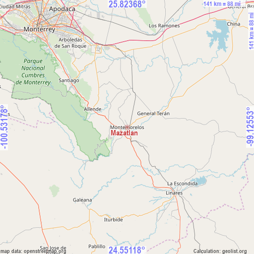
Mazatlan GPS coordinates[2]
25° 11' 20.724" North, 99° 49' 43.14" West
| Map corner | latitude | longitude |
|---|---|---|
| Upper-left | 25.82368°, | -100.53178° |
| Center: | 25.18909°, | -99.82865° |
| Lower-right: | 24.55118°, | -99.12553° |
| Map W x H: | 141.5×141.5 km | = 87.9×87.9mi |
| max Lat: | 32.7° ⇑8% North |
| Mazatlan: | 25.18909° |
| min Lat: | ⇓92% South 14.53588° |
| min Long | Mazatlan | max Long |
| -117.105° | -99.82865° | -86.73105° |
| W 38.1%⇐ | ⇒61.9% E |
Elevation
Elevation of Mazatlan is 422 m = 1385 ft, and this is 831.7 m = 2729 ft below average elevation for this country.
| Max E: |
3497 m = 11473 ft | 69.9% |
| Avg. | 1253.7 m = 4113 ft | |
| Mazatlan | 422 m = 1385 ft | |
Min E: |
-1 m = -3 ft | 30.1% |
See also: Mazatlan elevation on elevation.city.
Geographical zone
Mazatlan is located in North temperate zone (between Tropic of Cancer and the Arctic Circle). Distance of this Northern Tropic circle is 194.8 km =121 mi to South.| Distance of | km | miles | from Mazatlan |
|---|---|---|---|
| North Pole | 7206.3 | 4477.8 | to North |
| Arctic Circle | 4600.4 | 2858.6 | to North |
| Tropic Cancer | 194.8 | 121 | to South |
| Equator | 2800.8 | 1740.3 | to South |


Nearby cities:
15 places around Mazatlan: (largest is in red/bold)
• Atongo de Abajo
24.7 km =15.3 mi,  319°
319°
• Ciudad General Terán
16.5 km =10.3 mi,  62°
62°
• Ciudad de Allende
21.1 km =13.1 mi,  297°
297°
• Congregación Calles
11.4 km =7.1 mi,  290°
290°
• El Fraile
21.5 km =13.4 mi,  330°
330°
• Hualahuises
37.4 km =23.2 mi,  155°
155°
• La Escondida
44.2 km =27.5 mi,  134°
134°
• Palmitos
33.6 km =20.9 mi, 334°
• Paso Hondo
17.4 km =10.8 mi,  306°
306°
• Pueblo Nuevo
33.5 km =20.8 mi,  11°
11°
• Rayones
31.1 km =19.3 mi,  232°
232°
• Río Verde
43 km =26.7 mi,  138°
138°
• San Juan
39.3 km =24.4 mi,  358°
358°
• Santa Isabel y Dolores
38.9 km =24.2 mi, 7°
• Santiago
41.8 km =26 mi, 308°
Sources, notices
• [Note1] Compared only with cities in Mexico existing in our database
• [Src1] Map data: © OpenStreetMap contributors (CC-BY-SA)
• [Src2] Other city data from geonames.org with taken over terms of usage.
• [Src3] Geographical zone / Annual Mean Temperature by Robert A. Rohde @ Wikipedia
