Río Verde geodata
Río Verde (Nuevo León) is a populated place; located in Mexico in America/Monterrey (GMT-6) time zone. With population of 1,125 people, there are 7707 cities with bigger population in this country. Compared to other cities in Mexico, 91.7% of cities are located further ↓South; 57.5% of cities are located further →East and 72% of cities have higher elevation than Río Verde. Note1


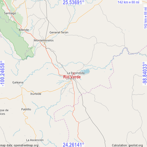
Río Verde GPS coordinates[2]
24° 54' 2.916" North, 99° 32' 36.42" West
| Map corner | latitude | longitude |
|---|---|---|
| Upper-left | 25.53691°, | -100.24658° |
| Center: | 24.90081°, | -99.54345° |
| Lower-right: | 24.26141°, | -98.84033° |
| Map W x H: | 141.8×141.8 km | = 88.1×88.1mi |
| max Lat: | 32.7° ⇑8.3% North |
| Río Verde: | 24.90081° |
| min Lat: | ⇓91.7% South 14.53588° |
| min Long | Río Verde | max Long |
| -117.105° | -99.54345° | -86.73105° |
| W 42.5%⇐ | ⇒57.5% E |
Elevation
Elevation of Río Verde is 330 m = 1083 ft, and this is 923.7 m = 3031 ft below average elevation for this country.
| Max E: |
3497 m = 11473 ft | 72% |
| Avg. | 1253.7 m = 4113 ft | |
| Río Verde | 330 m = 1083 ft | |
Min E: |
-1 m = -3 ft | 28% |
See also: Mexico elevation on elevation.city.
Geographical zone
Río Verde is located in North temperate zone (between Tropic of Cancer and the Arctic Circle). Distance of this Northern Tropic circle is 162.8 km =101.2 mi to South.| Distance of | km | miles | from Río Verde |
|---|---|---|---|
| North Pole | 7238.4 | 4497.7 | to North |
| Arctic Circle | 4632.5 | 2878.5 | to North |
| Tropic Cancer | 162.8 | 101.2 | to South |
| Equator | 2768.7 | 1720.4 | to South |


Nearby cities:
15 places around Río Verde: (largest is in red/bold)
• Ciudad General Terán
42.2 km =26.2 mi,  340°
340°
• Congregación Calles
53.4 km =33.2 mi,  312°
312°
• Galeana
54.4 km =33.8 mi,  261°
261°
• Garza Valdez
45.4 km =28.2 mi,  159°
159°
• General Lucio Blanco
23.5 km =14.6 mi,  142°
142°
• Guadalupe
7.3 km =4.5 mi,  95°
95°
• Hualahuises
13.4 km =8.3 mi, 261°
• Iturbide
41.3 km =25.7 mi,  241°
241°
• La Escondida
2.7 km =1.7 mi,  72°
72°
• Linares
5.4 km =3.4 mi,  207°
207°
• Mazatlan
43 km =26.7 mi,  318°
318°
• Pablillo
57.1 km =35.5 mi,  233°
233°
• Rayones
55 km =34.2 mi,  283°
283°
• Villa Mainero
38.6 km =24 mi,  190°
190°
• Villagrán
47.9 km =29.8 mi,  173°
173°
Sources, notices
• [Note1] Compared only with cities in Mexico existing in our database
• [Src1] Map data: © OpenStreetMap contributors (CC-BY-SA)
• [Src2] Other city data from geonames.org with taken over terms of usage.
• [Src3] Geographical zone / Annual Mean Temperature by Robert A. Rohde @ Wikipedia
